Update on Tropical Storm Chantal
By Space Coast Daily // July 8, 2013
Moving West Northwest
ABOVE VIDEO: The third named storm of the 2013 Atlantic Hurricane season was named late Sunday evening. UF Meteorologist Jeff Huffman has the latest on Chantal and the forecast path. (Video Courtesy of the University of Florida)
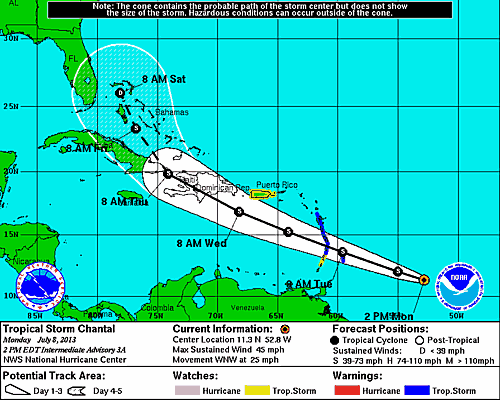
BREVARD COUNTY, FLORIDA — The National Hurricane Center in Miami has issued an updated advisory on Tropical Storm Chantal.
As of the latest update, Chantal is located at 11.3°N 52.8°W, moving West-Northwest at 25 miles per hour, with maximum sustained winds at 45 miles per hour. Chantal is expected to continute on a West-Northwest path at about the same forward speed over the next 48 hours. The center of Chantal should reach the Lesser Antilles by early Tuesday and move into the Eastern Caribbean Sea later on Tuesday. A Tropical Storm Warning is in effect for
- Barbados
- Dominica
- Saint Lucia
- Martinique
- Guadeloupe
A Tropical Storm Watch is in Effect for:
- Saint Vincent
- Puerto Rico..Including Vieques & Culbera
A Tropical Storm Warning means that Tropical Storm conditions are expected somewhere within the warning area in this case within 24 to 36 hours.
See the wind force projection chart and the projection cone map below.
STAY TUNED TO SPACECOASTDAILY.COM FOR UPDATES ON TROPICAL STORM CHANTAL