Tropical Storm Erika Dissipating, Path Tracking Into Gulf of Mexico
By Space Coast Daily // August 29, 2015
degenerating to a trough of low pressure
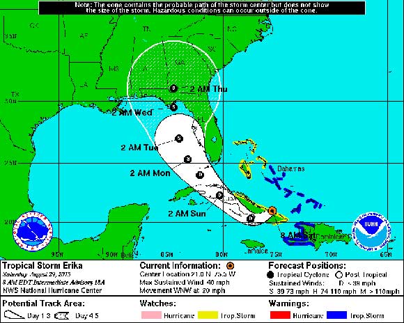
NATIONAL WEATHER SERVICE – The Saturday 8 a.m. National Hurricane Center Update on Tropical Storm Erika shows the storm dissipating and remains poorly organized. The forecast is it will continue to weaken as it moves west-northwest across Cuba today into tonight.
8:00 AM EDT Sat Aug 29
Location: 21.0°N 75.5°W
Moving: WNW at 20 mph
Min pressure: 1010 mb
Max sustained: 40 mph
The forecast track continues to edge westward with the system with Erika moving northward over the eastern Gulf of Mexico as a Tropical Depression or weak Tropical Storm. Projected strength and track remains somewhat uncertain, but increasing rain chances are expected Sunday into early next week with heavy rainfall possible across the region.
Surface observations from Cuba and reports from a U.S. Air Force Reserve Hurricane Hunter aircraft suggest that Erika is degenerating to a trough of low pressure. If subsequent data confirm this, advisories will be discontinued later this morning.
Erika is located about 55 miles east-northeast of Holguin, Cuba, as of 8 a.m. EDT, moving toward the west-northwest near 20 mph. This general motion is expected to continue through tonight. A turn toward the northwest and a decrease in forward speed are expected on Sunday. On the forecast track, Erika or its remnants will continue to move near or over portions of eastern Cuba today and move near central Cuba tonight.

Maximum sustained winds are 40 mph. Tropical storm conditions across Haiti will gradually subside this morning, and will continue in portions of the Turks and Caicos Islands and the southeastern Bahamas for the next few hours. Tropical storm conditions are possible over eastern Cuba today.
Erika is expected to produce total rainfall accumulations of 3 to 6 inches with maximum amounts of 10 inches possible across portions of the Dominican Republic, Haiti and eastern Cuba through Sunday. These rains could cause life-threatening flash floods and mud slides. In addition, the outer bands of Erika are also expected to produce rainfall amounts of 1 to 3 inches across the Turks and Caicos Islands as well as the southeastern and central Bahamas through Sunday.
Get the latest on this tropical cyclone by visiting the NHC website atwww.hurricanes.gov
For latest updates on Erika, visit the National Hurricane Center website at www.nhc.noaa.gov.


