Though today is the last day of hurricane season, the threat of severe weather is not over for central Florida. Beginning this month and lasting through April, the region will experience the impacts of one of the strongest El Niño events seen in almost a decade. (Image by Dave Frisch)
BREVARD COUNTY, FLORIDA – Though today is the last day of hurricane season, the threat of severe weather is not over for central Florida. Beginning this month and lasting through April, the region will experience the impacts of one of the strongest El Niño events seen in almost a decade.
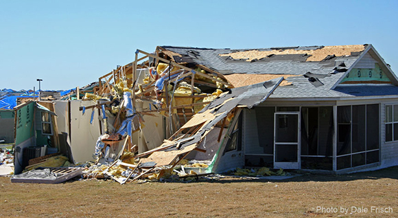
The greatest potential for severe weather will be in January and February, when strong, tornado-producing storms could occur once every one to two weeks.
An El Niño event occurs when tropical waters in the Pacific Ocean are warmer than average, setting the stage for changes in weather patterns worldwide.
In central Florida this will mean more frequent, and stronger, thunderstorms during the winter, with a significant increase in the possibility of night-time tornadoes.
Chuck Bogle
“Most people think of thunderstorms as only happening in the afternoon,” said Melbourne Fire Chief Chuck Bogle.
“However, during an El Niño year, the risk for severe storms and tornadoes is much greater in the overnight hours. We advise everyone to have a plan, to monitor weather forecasts, and to get a NOAA Weather Radio or to confirm they can receive Wireless Emergency Alerts on their mobile phones that will wake them up and give them a chance to get to safety in the event a tornado warning is issued.”
Meteorologists believe that this year’s El Niño could become as strong as the El Niño events in 1998 and 2007 — the two deadliest years for tornadoes in Florida history when strong storms spawned multiple tornadoes that killed a total of 63 people.
According to the National Weather Service (NWS), the average warning time for a tornado is 15 minutes, but this window can be as short as 3 minutes.
Citizen safety depends on being prepared in advance and keeping alert during the winter storm season. The NWS recommends the following safety and preparation tips:
Monitor local television and radio for severe weather situations. Threats are typically identified a few days in advance, with more specific information provided one day in advance.
Identify a safe place inside your home (i.e. small interior room on the lowest floor, far from windows) and ensure all family members are aware of the location and know to go there in the event of a tornado warning.
Get a dependable audible-alerting feature or device, like a programmed NOAA Weather Radio or a mobile phone enabled with the Wireless Emergency Alert feature.
If you live in a mobile home, RV or boat, make plans to stay with family or friends when severe overnight storms are in the forecast. If you can’t leave, identify the closest sturdy shelter, such as a clubhouse or laundry room, and go there immediately if a warning is issued for your location.
If a tornado warning is issued for your location:
Immediately move to your shelter and remain in place until the threat passes.
If you have time, put on your shoes and place your charged cell phone in your pocket.
Put on a helmet or use a pillow to protect your head – most deaths occur from blunt force trauma to the head from blowing debris.