National Weather Service: Potentially Strong Storms Coming To Brevard, Could Turn Severe
By US National Weather Service // January 14, 2016
Severe Storms Late Thursday Night Into Friday
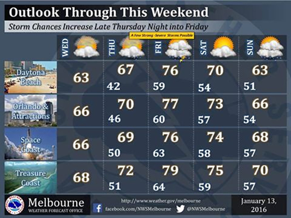
BREVARD COUNTY, FLORIDA – The outlook through the weekend continues to show potential for a few strong to severe storms late Thursday night into Friday, according to the U.S. National Weather Service.
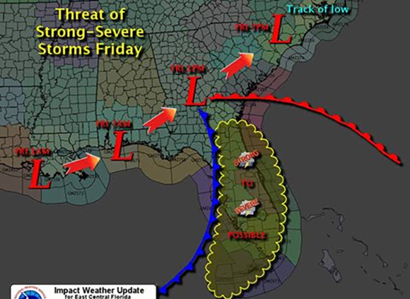
While some minor timing differences remain, weather models have come into much better agreement regarding the strength and track of a low pressure area, which is forecast to move across the northeast Gulf of Mexico during the pre-dawn hours Friday, and then from the Florida panhandle across Georgia and the Carolinas during the day.
Strengthening wind fields coupled with increasing moisture and instability are expected to spread northward ahead of the low, as a warm front develops and lifts northward across the peninsula late Thursday night.
Additionally, sufficient wind shear is forecast to support rotating storms, which means there is some potential for the development of tornadoes.
This is the time of year when severe weather is more likely to occur overnight.

The National Weather Service reminds everyone now is a good time to think about how residents will be alerted to a severe weather warning while you are sleeping.
A NOAA Weather Radio can alert you that a severe weather warning has been issued by the NWS, 24/7.
CLICK HERE for more information.
Stay Tuned To Space Coast Daily For Updates