Special Satellites From Space Show Mass Power Outages Caused By Hurricane Matthew
By NASA // October 13, 2016
ON OCT 8 FPL REPORTED 400K WITHOUT POWER
(NASA EARTH) – After grazing Florida and Georgia, Hurricane Matthew plowed into South Carolina southeast of McClellanville as a category 1 storm.
Strong winds, falling trees, and storm surge flooding knocked out power in coastal areas of all three states.
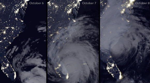
From space, the outages were clearly visible. The Visible Infrared Imaging Radiometer Suite (VIIRS) on the Suomi NPP satellite captured these three nighttime images of the Atlantic coast.
The image on the left was acquired at 3:14 a.m. Eastern Daylight Time on October 6, 2016; the middle image shows the same area at 3:14 a.m. on October 7; the image on the right was acquired at 2:14 a.m. on October 8.

The VIIRS images were captured by the sensor’s day-night band, which detects light in a range of wavelengths from green to near-infrared and uses filtering techniques to observe signals such as gas flares, city lights, and reflected moonlight.
Infrared observations collected by the GOES East satellite were layered on the VIIRS data to make the clouds associated with Matthew more visible. Notice how many cities and towns on the eastern coast of Florida lost power on October 7.

By the next day, power had been restored in some areas.
As of 1:00 p.m. Eastern Daylight Time on October 8, 2016, Florida Power & Light Company reported that 400,000 customers were without power.
In Georgia, 272,000 Georgia Power customers were in the dark. South Carolina Gas & Electric had 268,000 customers without power; Duke Energy had an additional 70,000 customers in the dark in South Carolina and 84,000 in North Carolina.

The map below is based on data from the power companies. In particular, Flagler County, Florida, and Calhoun County, South Carolina suffered many outages.
“Many hurricane-related deaths occur with power outages.

 Related Story:
Federal Govt. Continues To Ramp Up Resources, Support For Affected States By Hurricane Matthew
CLICK HERE FOR MORE SPACE NEWS FROM NASA


