HURRICANE TRACKER: Category 5 Irma Creeping Closer To Florida, Descends On Bahamas Tonight
By Space Coast Daily // September 7, 2017
SPACE COAST DAILY TV: Irma is now passing over Puerto Rico, with the Space Coast projected to be impacted early Monday, says NHC. Alan Zlotorzynzki reports live with the 11:00 p.m. Wednesday update.


BREVARD COUNTY, FLORIDA – The National Hurricane Center’s 8 a.m. update shows Irma moving over northern portions of Hispaniola Coasts with 180 max sustained winds and moving to the west-northwest at 17 mph.
On the forecast track, the eye of Irma should continue to move just north of the coast of Hispaniola today, be near the Turks and Caicos and southeastern Bahamas by this evening, and then be near the Central Bahamas by Friday.
Maximum sustained winds are near 180 mph (295 km/h) with higher gusts. Irma remains a category 5 hurricane on the Saffir-Simpson Hurricane Wind Scale with some fluctuations in intensity are likely during the next day or two.
An unofficial observation on Buck Island in the U.S. Virgin Islands has recently reported sutained winds of 106 mph (171 km/h) with a gust to 131 mph (211 km/h).
Hurricane-force winds extend outward up to 50 miles (85 km) from the center and tropical-storm-force winds extend outward up to 185 miles (295 km).
The latest Irma path projection that came out Wednesday shows the massive hurricane striking the Space Coast 8 a.m. Monday morning.
Irma is the strongest Atlantic hurricane since Wilma in 2005 which also recorded maximum sustained winds of 185 mph.
Based on NHC’s forecast, Irma’s path will shift to the north Saturday, making it a likely hit to the Florida Keys and South Florida on Sunday heading into Monday.

A Hurricane Warning is typically issued 36 hours before the anticipated first occurrence of tropical-storm- force winds, conditions that make outside preparations difficult or dangerous.

CLICK HERE TO DOWNLOAD THE APP FOR ANDROID
CLICK HERE TO DOWNLOAD APP FOR IPHONE AND IPAD
STORM SURGE
The combination of a dangerous storm surge and large breaking waves will cause water levels to rise by as much as 7 to 11 feet above normal tide levels along the coasts of the extreme northern Leeward Islands within the hurricane warning area near and to the north of the center of Irma.
Near the coast, the surge will be accompanied by large and destructive waves.
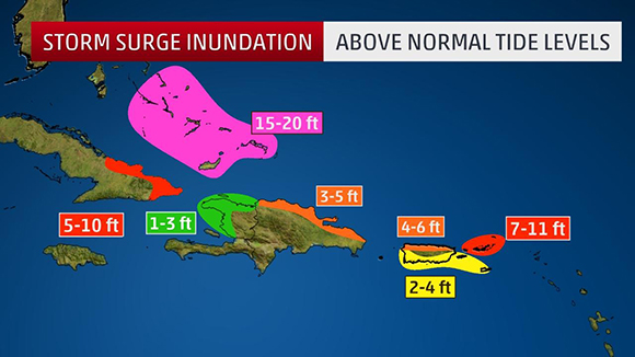
NHC says the combination of a dangerous storm surge and the tide will cause normally dry areas near the coast to be flooded by rising waters moving inland from the shoreline. The water is expected to reach the following heights above ground if the peak surge occurs at the
time of high tide.
Turks and Caicos Islands…15 to 20 ft
Southeastern and central Bahamas…15 to 20 ft
Northwestern Bahamas…4 to 7 ft
Northern coast of the Dominican Republic…3 to 5 ft
Northern coast of Haiti and the Gulf of Gonave…1 to 3 ft
Northern coast of Cuba in the warning area…5 to 10 ft
Water levels around Puerto Rico should subside today.
RAINFALL
Irma is expected to produce the following rain accumulations through Saturday:
Northeast Puerto Rico and the British and U.S. Virgin Islands…An
additional 2 to 4 inches.
Much of the Bahamas and the Turks and Caicos…8 to 12 inches,
isolated 20 inches.
Northern Dominican Republic and northern Haiti…4 to 10 inches,
isolated 15 inches.
Eastern and Central Cuba…4 to 10 inches, isolated 15 inches.
Southern Haiti…1 to 4 inches.
In all areas this rainfall may cause life-threatening flash floods and mudslides.
HURRICANE CATEGORIES
ABOVE VIDEO: During a hurricane you usually hear meteorologists refer to its intensity by categories. If you don’t know the difference between a category 1 and a category 5 hurricane, The Weather Channel meteorologist Mark Elliot breaks it down for you. (The Weather Channel Video)
HURRICANE PREPARATION
ABOVE VIDEO: Space Coast Daily Special Weather Correspondent Danny Treanor offers his expert tips about surviving the upcoming hurricane season on the Space Coast. Treanor has been Central Florida’s premier weatherman for five decades. Part two below.
ABOVE VIDEO: Surviving hurricane season on the Space Coast part 2.
ABOVE VIDEO: Don’t wait until a storm is heading your way! Survive a hurricane with these safety precautions. (Howcast Video)
Step 1: Plan ahead
Plan ahead. Know the location of local shelters and how you’ll evacuate if you don’t have a car. If you have family members with special medical needs, ask local officials if there’s a registry so they get help in the event of power outages.
Pick a place for family members to meet in case you become separated, and designate an out-of-town friend as the person everyone calls to report that they’re safe. Get flood insurance if you don’t already have it.
Tip
Make sure you know how to shut off electricity, gas, and water in case you’re instructed to do so.
Step 2: Be prepared
Have the following supplies on hand at the start of hurricane season: a 3-day supply of water that provides 1 gallon per person per day; a 3-day supply of non-perishable food that doesn’t require cooking; a flashlight and extra batteries; a battery-powered radio that can receive broadcasts from the National Oceanic and Atmospheric Administration; a first-aid kit; and a 7-day supply of medications.
Tip
The Atlantic and Central Pacific hurricane season runs from June 1 to November 30; the Eastern Pacific is from May 15 through November.
 Related Story:
HURRICANE TRACKER: Irma – Second Strongest Hurricane Recorded In Atlantic History With 185 MPH Winds
Step 3: Get ready
If a hurricane warning is issued — meaning one is expected in the next 36 hours — bring in anything that can be tossed around by the wind; close and board up all windows and doors with 5/8″ marine plywood, unless you have hurricane shutters; clear rain gutters and downspouts; trim trees and shrubs; put your refrigerator and freezer on the coldest setting; and fill your car’s gas tank in case you’re ordered to evacuate.
Step 4: Go to a safe place
If you live on the first or 2nd floor of a high rise, make plans to take refuge with neighbors between floors 3 and 10 when the storm begins. Residents who live above the 10th floor should evacuate, as should mobile home dwellers and anyone living on a floodplain, near a river, or on an inland waterway.
Step 5: Do last-minute preparations
Shortly before the storm is expected to start, fill your bathtub with water so you have an extra supply on hand. Unplug small appliances and sensitive electronics, and turn off propane tanks.
Step 6: Ride out the storm
When the storm starts, stay away from windows and glass doors and avoid using the phone. Go to your home’s lowest level and stay in an interior room, closet, or hallway. Have a mattress or pillow to protect your head. Monitor weather conditions on your radio and don’t leave your safe place until local officials say it’s okay to do so.
Step 7: Avoid post-storm dangers
If you lose electricity, keep circuit breakers turned off until power is restored, then check for frayed wires. If you see any, call the power company. Leave the house immediately if you smell gas. If you’re returning home, don’t enter your house if floodwaters remain around the building; you see loose power lines or structural damage; or you smell a gas leak. If you have any safety concerns at all, stay elsewhere until your home is checked by a building inspector or structural engineer.
CLICK HERE FOR BREVARD COUNTY NEWS


