Tropical Depression 16 Forecasted To Become Hurricane Nate, Florida Panhandle Could Be In Path
By Space Coast Daily // October 4, 2017
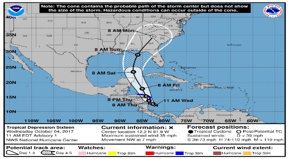
forecast to become a hurricane later in weekend

BREVARD COUNTY, FLORIDA — Satellite images indicate that the area of low pressure in the southwestern Caribbean Sea has become better organized since yesterday and is now tropical depression 16.
The storm is expected to become Nate later on today and will be the 14th named storm of the 2017 Atlantic Hurricane season and seventh named storm in just the last 48 days.
The tropical depression is moving northwest at approximately seven miles per hour and is expected to be near the coast of Nicaragua early Thursday and move across Nicaragua and eastern Honduras late Thursday.
The storm is forecast to emerge into the northwestern Caribbean Sea on Friday and continue strengthening over the Gulf of Mexico.
 Related Story:
NWS: Gale Warning In Effect In Brevard County Until 10 a.m. Wednesday, Expect 40 mph Wind Gusts
The latest storm could affect portions of the northern Gulf Coast as a hurricane this weekend, with direct impacts from wind, storm surge, and heavy rainfall. However, it is too early to specify the timing or magnitude of these impacts.
Residents along the Gulf Coast from Louisiana to Florida should monitor the progress of this system for the next several days and heed any advice given by local officials.
Hurricane hunters are currently flying into the system and further updates will follow through out the day.
STAY TUNED TO SPACE COAST DAILY FOR UPDATES
CLICK HERE FOR BREVARD COUNTY NEWS