Hurricane Michael’s Winds Reach 150-mph, First Ever Extreme Wind Warning Issued for Region
By Space Coast Daily // October 10, 2018
Michael forecast to be largest hurricane to ever strike region
TALLAHASSEE, FLORIDA– Remarkably, Category 4 Hurricane Michael continues to grow in strength as it approaches the Florida Panhandle this morning and early afternoon.
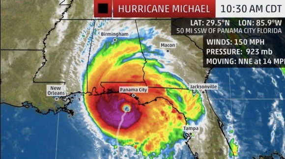
The 11:30 a.m. advisory from the National Hurricane Center reports that Hurricane Michael has sustained winds of 150 mph.
Hurricane Michael is forecast to be the largest hurricane on record to impact the Panhandle and Big Bend area of Florida. Michael is an upper-level category 4 hurricane. Category 5 storms occur when winds reach 157 mph or higher.
As a result of the strengthening, the National Weather Service in Tallahassee has issued the regions first ever extreme wind warning effective until 2:15 p.m. EDT.
An extreme wind warning (EWW) is issued when a landfalling hurricane is expected to bring winds of 115 mph, or above to a specific location. The warning is issued just prior to when the strongest winds of the eyewall are expected to impact an area.
The warning is to be issued for the smallest area possible, and be valid for times of two hours or less, though some warnings have been issued for three hours.
The warning is relatively new to the NWS which developed the EWW in response to confusion resulting from the landfall of Hurricane Katrina.

NWS offices in Jackson and New Orleans/Baton Rouge issued 11 tornado warnings for areas that would not experience an actual tornado but would experience extreme wind speeds commonly associated with tornadoes.
Hurricane Michael is forecast to deliver catastrophic damage to Gulf County in the Panhandle of Florida, Southern Bay County in the Panhandle of Florida and Southwestern Franklin County in the Big Bend of are of Florida.
At 11:30 a.m. the eye of Hurricane Michael was located approximately 50 miles SSW of Panama City, Florida.
The Following is the bulletin issued by the NWS in Tallahassee.

BULLETIN - EAS ACTIVATION REQUESTED
Extreme Wind Warning
National Weather Service Tallahassee FL
1111 AM EDT WED OCT 10 2018

The National Weather Service in Tallahassee has issued a

* Extreme Wind Warning for...
  Gulf County in the Panhandle of Florida...
  Southern Bay County in the Panhandle of Florida...
  Southwestern Franklin County in Big Bend of Florida...

* Until 215 PM EDT/115 PM CDT/.

* At 1109 AM EDT/1009 AM CDT/, National Weather Service Doppler
  radar indicated extreme winds in excess of 130 mph, associated
  with the eyewall of Hurricane Michael, were moving onshore. THIS
  IS AN EXTREMELY DANGEROUS AND LIFE-THREATENING SITUATION!

PRECAUTIONARY/PREPAREDNESS ACTIONS...

TAKE COVER NOW! Treat these imminent extreme winds as if a tornado
was approaching and move immediately to the safe room in your
shelter. Take action now to protect your life!

A Tornado Watch remains in effect until 500 PM EDT/400 PM CDT/ for
Big Bend of and the Panhandle of Florida.
CLICK HERE FOR BREVARD COUNTY NEWS


