National Hurricane Center Tracks Potential Tropical Storm ‘Fred’ Near Puerto Rico
By Space Coast Daily // August 10, 2021
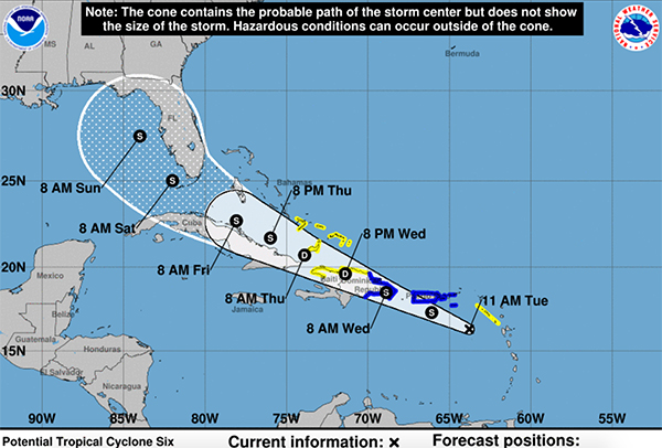
system is currently carrying 35 mph max sustained winds

BREVARD COUNTY, FLORIDA – National Hurricane Center is continuing to track a potential tropical storm forming in the Caribbean that is expected to become a Tropical Storm later today.
The system is currently carrying 35 mph max sustained winds and is moving to the west-northwest at 18 mph.
The latest weather report shows potential ‘Fred’ will maintain as a tropical storm starting Tuesday, weaken by Wednesday night and strengthen back up to a tropical storm Thursday night before making landfall on South Florida by Saturday morning.
This system is not expected to become a hurricane at this time, which has to reach 74 mph max sustained winds to be classified as a category 1 hurricane.
At this time, the forecast track shows the disturbance is expected to pass near or over the U.S. Virgin Islands and Puerto Rico later today and tonight, be near or over Hispaniola on Wednesday, and be near the southeastern Bahamas and the Turks and Caicos Islands Thursday.
A Tropical Storm Warning is in effect for…
* Puerto Rico, including Culebra and Vieques
* U.S. Virgin Islands
* Dominican Republic on the south coast from Punta Palenque
eastward and on the north coast from Cabo Frances Viejo eastward


