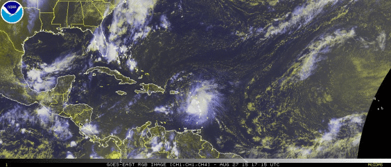
Tropical Storm Erika Update: Still On Track To Impact Florida As Hurricane
By Space Coast Daily // August 27, 2015


NATIONAL WEATHER SERVICE – The 5 p.m. Thursday National Hurricane Center update on Tropical Storm #Erika had max sustained wind speeds of 45 mph and movement toward the west-northwest at 15 mph.
5:00 PM AST Thu Aug 27
Location: 16.6°N 64.0°W
Moving: WNW at 15 mph
Min pressure: 1006 mb
Max sustained: 45 mph
The forecast track has Erika moving over the Bahamas this weekend and nearing Florida Sunday evening.
For the latest information on Erika, please visit the NWS National Hurricane Center website at http://www.nhc.noaa.gov.
Remember, the time to get a plan in place is BEFORE a tropical system threatens your area. If you don’t already have a plan, now is the time to make a safety plan and be ready to act if necessary. Visithttp://www.ready.gov for more information.
NATIONAL HURRICANE CENTER REPORT

Tropical Storm Erika is producing very heavy rain over portions of the Leeward Islands, which should spread over the Virgin Islands and Puerto Rico tonight and early Friday.
Total rainfall accumulations of 4 to 8 inches – with maximum amounts of 12 inches possible – which could produce flash floods and mud slides. More than 12 inches of rain has fallen in Dominica, with reports of fatalities on that island.
Erika is centered about 175 miles west of Guadeloupe, moving toward the west-northwest near 15 mph, and this general motion is expected to continue for the next 48 hours.
On the forecast track, the center of Erika will move near the Virgin Islands this evening, move near or over Puerto Rico tonight, and move near or over the Dominican Republic on Friday.
A Tropical Storm Warning continues for Anguilla, Saba, St. Eustatius, St. Maarten, Montserrat, Antigua, Barbuda, St. Kitts, Nevis, St. Martin, St. Barthelemy, Puerto Rico, Vieques, Culebra, the U.S. and British Virgin Islands, and the north coast of the Dominican Republic from Cabo Engano to the border of Haiti,.
A Tropical Storm Watch continues for Guadeloupe, the Southeast Bahamas and the Turks & Caicos Islands.
Maximum sustained winds are near 45 mph. No significant change in strength during the next 48 hours is forecast. Because of the marginal upper-level wind environment and potential interaction with land over the next few days, there is unusually high uncertainty in the forecast intensity, especially days 3 to 5.
Get the latest on this tropical cyclone by visiting the NHC website atwww.hurricanes.gov


