Tropical Storm Kate Strengthening, Located 20 Miles Southeast of Cat Island In Bahamas.
By National Hurricane Center // November 9, 2015
11th named storm of the HURRICANE SEASON
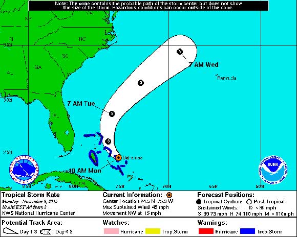
NATIONAL HURRICANE CENTER – Tropical Storm Kate, the 11th named storm of the 2015 Atlantic hurricane season, is strengthening and is located about 20 miles southeast of Cat Island in the Bahamas.
10:00 AM EST Mon Nov 9
Location: 24.5°N 75.3°W
Moving: NW at 15 mph
Min pressure: 1008 mb
Max sustained: 45 mph
According to the National Hurricane Center, as of 10 a.m. Monday, Kate had maximum sustained winds of 45 miles per hour and is moving northwest at 15 miles per hour.
Kate is expected to produce total rain accumulations of 1 to 3 inches over the Bahamas through tonight.
NATIONAL HURRICANE CENTER FORECAST:
At 1000 AM EST (1500 UTC), the center of Tropical Storm Kate was
located near latitude 24.5 North, longitude 75.3 West. Kate is
moving toward the northwest near 15 mph (24 km/h).  A turn toward
the north is expected tonight, followed by a turn toward the
north-northeast on Tuesday.  On the forecast track, the center of
Kate is forecast to pass near or over portions of the central
Bahamas during the next few hours and near or over portions
of the northwestern Bahamas this afternoon and tonight.

Maximum sustained winds have increased to near 45 mph (75 km/h)
with higher gusts.  Additional strengthening is forecast during the
next 48 hours.

Tropical-storm-force winds extend outward up to 90 miles (150 km)
north of the center.

The estimated minimum central pressure based on data from an Air
Force Reserve reconnaissance aircraft is 1008 mb (29.77 inches).

HAZARDS AFFECTING LAND
----------------------
WIND:  Tropical storm conditions are expected to continue over
portions of the central Bahamas for the next few hours and will
spread over portions of the northwestern Bahamas this afternoon.

RAINFALL:  Kate is expected to produce total rain accumulations of
1 to 3 inches over the Bahamas through tonight.
STAYTUNED TO SPACECOASTDAILY.COM FOR UPDATES


