HURRICANE MATTHEW UPDATE: Storm Expected To Skirt Brevard County Coast Late Thursday Night
By Space Coast Daily // October 5, 2016
Curently a category 4 hurricane
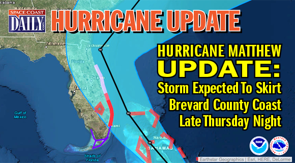
BREVARD COUNTY, FLORIDA – Hurricane Matthew’s latest max sustained wind latest reading from the National Hurricane Center was recorded at 130 mph.
Projections from the hurricane experts say conditions on the Space Coast will be felt by late Thursday evening, with tropical storm conditions possible by early Thursday.
As of the 11 p.m., Matthew was about 50 miles east northeast of Guantanamo Bay.
CLICK HERE TO FIND YOUR EVACUATION ZONE
Tropical storm force winds extend for 175 miles from the center.
Matthew remains a category 4 hurricane on the Saffir-Simpson Hurricane Wind Scale.
According to the National Hurricane Center, Matthew continues moving toward the north near 8 mph and is expected to continue to move through the evening.
A turn toward the north-northwest is expected on Wednesday, followed by a northwest turn Wednesday night.
 Related Story:
UPDATE: Brevard Public Schools Closed Thursday and Friday, All Activities Are Cancelled
Earlier today, Brevard Public Schools had just completed its EOC policy meeting and BPS Superintendent Desmond Blackburn announced that all BPS schools will be closed both Thursday and Friday, October 6 – 7, due to inclement weather and all associated activities are cancelled through the weekend.
School will remain open tomorrow, Wednesday, October 5, which is a regularly scheduled early release day.
The next advisory is at 2 a.m.
STAY TUNED TO SPACE COAST DAILY FOR UPDATES


