How Do Hurricanes Form? NASA Answers The Question and More
By NASA // September 10, 2017

(NASA) – Hurricanes are the most violent storms on Earth. People call these storms by other names, such as typhoons or cyclones, depending on where they occur.
The scientific term for ALL of these storms is tropical cyclone. Only tropical cyclones that form over the Atlantic Ocean or eastern and central Pacific Ocean are called “hurricanes.”

Whatever they are called, tropical cyclones all form the same way.
Tropical cyclones are like giant engines that use warm, moist air as fuel. That is why they form only over warm ocean waters near the equator. This warm, moist air rises and condenses to form clouds and storms.

As this warmer, moister air rises, there’s less air left near the Earth’s surface. Essentially, as this warm air rises, this causes an area of lower air pressure below.

This starts the ‘engine’ of the storm. To fill in the low pressure area, air from surrounding areas with higher air pressure pushes in.
That “new” air near the Earth’s surface also gets heated by the warm ocean water so it also gets warmer and moister and then it rises.

As the warm air continues to rise, the surrounding air swirls in to take its place. The whole system of clouds and wind spins and grows, fed by the ocean’s heat and water evaporating from the surface.
As the storm system rotates faster and faster, an eye forms in the center. It is vey calm and clear in the eye, with very low air pressure.

Tropical cyclones usually weaken when they hit land, because they are no longer being “fed” by the energy from the warm ocean waters. However, when they move inland, they can drop many inches of rain causing flooding as well as wind damage before they die out completely.
There are five types, or categories, of hurricanes. The scale of categories is called the Saffir-Simpson Hurricane Scale and they are based on wind speed.
How Does NASA Study Hurricanes?
Our satellites gather information from space that are made into pictures.
Some satellite instruments measure cloud and ocean temperatures.
Others measure the height of clouds and how fast rain is falling. Still others measure the speed and direction of winds.
We also fly airplanes into and above hurricanes. The instruments aboard planes gather details about the storm. Some parts are too dangerous for people to fly into. To study these parts, we use airplanes that operate without people.
To learn more about how we study hurricanes, visit: https://www.nasa.gov/mission_pages/hurricanes/main/index.html
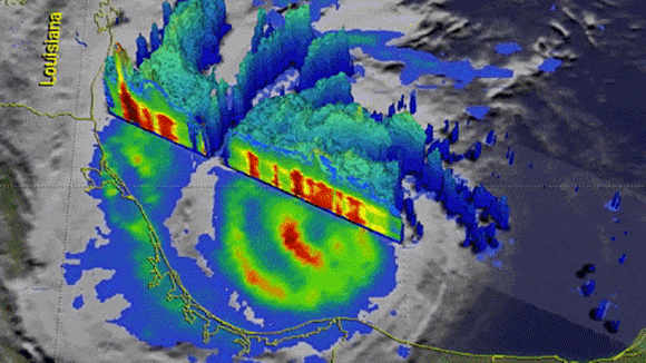
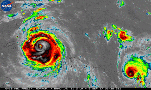
We’re using our unique vantage point in space to provide observations and data of Hurricane Irma and other tropical storms. Hurricanes Irma and Jose are seen here in a 12-hour long infrared loop.
Scientists monitor storms in infrared to closely monitor clouds and storm intensity. We continue to provide satellite imagery for these storms, tracking its trajectory, force and precipitation to inform forecasters at the National Hurricane Center.
As these storms continue their westward drive in the coming days, they will be passing over waters that are warmer than 30 degrees Celsius (86 degrees Fahrenheit)—hot enough to sustain a category 5 storm. Warm oceans, along with low wind shear, are two key ingredients that fuel and sustain hurricanes.
Get the latest imagery and data from us at www.nasa.gov/hurricane
CLICK HERE FOR BREVARD COUNTY NEWS


