HURRICANE TRACKER: Irma Jumps To Category 5 with 175 MPH Winds, Leeward Islands Brace For Impact
By Space Coast Daily // September 5, 2017
Max Sustained Winds of 175 MPH

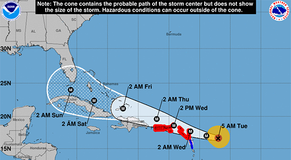
BREVARD COUNTY, FLORIDA – Hurricane Irma has taken a drastic turn for the worse as the latest report from the National Hurricane Center has shown Irma pick up over 25 mph in wind speed in less than three hours.
Irma is now a Category 5 hurricane with 175 mph max sustained winds and moving to the west at 14 mph.
A NOAA Hurricane Hunter plane is scheduled to be in the eye of Irma within the hour.
A turn toward the west-northwest is expected for tonight, according to the National Hurricane Center.
Hurricane warnings have been initiated for Antigua, Barbuda, British Virgin Islands, Anguilla, Culebra, Montserrat, Nevis, Puerto Rico, Saba, St. Eustatius, Sint Maarten, Saint Martin, St. Kitts, Saint Barthelemy and U.S. Virgin Islands
Hurricane watches have also been initiated for Guadeloupe, Dominican Republic from Cabo Engano to the northern border with
Haiti.
A Hurricane Warning is typically issued 36 hours before the anticipated first occurrence of tropical-storm- force winds, conditions that make outside preparations difficult or dangerous.
STORM SURGE
The combination of a dangerous storm surge and large breaking waves will cause water levels to rise by as much as 7 to 11 feet above normal tide levels along the coasts of the extreme northern Leeward Islands within the hurricane warning area near and to the north of the center of Irma.
Near the coast, the surge will be accompanied by large and destructive waves.
NHC says the combination of a dangerous storm surge and the tide will cause normally dry areas near the coast to be flooded by rising waters moving inland from the shoreline. The water is expected to reach the following heights above ground if the peak surge occurs at the
time of high tide.
British and U.S. Virgin Islands except St. Croix…7 to 11 ft
Northern coast of Puerto Rico…2 to 4 ft
Southern coast of Puerto Rico and St. Croix…1 to 2 ft
RAINFALL
Irma is expected to produce total rainfall accumulations of 4 to 8 inches with isolated maximum amounts of 12 inches across the northern Leeward Islands, the British and U.S. Virgin Islands, and Puerto Rico. These rainfall amounts may cause life-threatening flash floods and mudslides.
HURRICANE CATEGORIES
ABOVE VIDEO: During a hurricane you usually hear meteorologists refer to its intensity by categories. If you don’t know the difference between a category 1 and a category 5 hurricane, The Weather Channel meteorologist Mark Elliot breaks it down for you. (The Weather Channel Video)
HURRICANE PREPARATION
ABOVE VIDEO: Space Coast Daily Special Weather Correspondent Danny Treanor offers his expert tips about surviving the upcoming hurricane season on the Space Coast. Treanor has been Central Florida’s premier weatherman for five decades. Part two below.
ABOVE VIDEO: Surviving hurricane season on the Space Coast part 2.
CLICK HERE FOR BREVARD COUNTY NEWS


