HURRICANE DORIAN 8 A.M. UPDATE: NHC Track Shifts South, Intensifies to Category 2 Storm; Now Predicted to Hit Tuesday
By Space Coast Daily // August 30, 2019
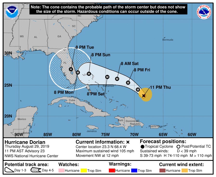
11 P.M. TRACK FORECAST CONTINUED MOVEMENT SOUTH FROM BREVARD COUNTY TOWARD JUPITER
SPACE COAST DAILY TV HURRICANE UPDATE: Space Daily’s Chris Bonanno discusses the latest advisory issued by the National Hurricane Center on Hurricane Dorian as of 11 p.m. Thursday. The National Hurricane Center’s 11 p.m. track forecast continued the movement of the storm south showing Dorian making landfall as a very dangerous Category 4 hurricane near Jupiter, Florida.

BREVARD COUNTY, FLORIDA – Hurricane Dorian is forecast to be a dangerous Category 4 hurricane as it approaches Florida late this weekend, according to the National Weather Service in Melbourne, Florida.
Dorian is now a Category 2 hurricane with 105 mph winds, according to 53rd Weather Reconnaissance Squadron hurricane hunter planes.
The National Hurricane Center’s Thursday 11 p.m. track forecast continued the movement of the storm south showing Dorian making landfall as a very dangerous Category 4 hurricane near Jupiter, Florida.
The National Weather Service said that the potential impact location and timing will have more clarity by Friday afternoon as Dorian’s direction and eventual turn toward the west-northwest starts to become apparent.
The risk of life-threatening storm surge and hurricane-force winds this weekend continues to increase in the northwestern Bahamas, and hurricane watches could be issued there tonight or Friday.
Residents should have their hurricane plan in place and listen to the advice given by local emergency officials.
There is an increasing likelihood of life-threatening storm surge along portions of the Florida east coast late this weekend or early next week, although it is too soon to determine where the highest storm surge will occur.
Residents should have their hurricane plan in place, know if they are in a hurricane evacuation zone, and listen to advice given by local emergency officials.
The risk of devastating hurricane-force winds along the Florida east coast and peninsula late this weekend and early next week continues to increase, although it is too soon to determine where the strongest winds will occur.
Regardless of the exact track of Dorian, heavy rains are expected to occur over portions of the Bahamas, Florida, and elsewhere in the southeastern United States this weekend and into the middle of next week.
SPACE COAST DAILY TV HURRICANE DORIAN UPDATE: Watch the press conference held at Brevard County Emergency Management headquarters Thursday afternoon about Hurrican Dorian featuring Gov. Ron DeSantis, Sheriff Wayne Ivey, Congressman Bill Posey, BPS Vice-Chair Matthew Susin, State Representative Randy Fine, Brevard County Commission Chair Kristine Isnardi, Rep. Thad Altman and Sen. Debbie Mayfield.
 Related Story:
Hurricane Hunters Fly into Dorian, Find Storm Strengthening Over Warm Waters of Atlantic
“All indications are that by this Labor Day weekend, a powerful hurricane will be near or over the Florida peninsula,” the National Hurricane Center said.
Florida Governor Ron DeSantis issued Executive Order 19-189, declaring a state of emergency for counties in the path of Hurricane Dorian.
“It’s important for Floridians on the East Coast to monitor this storm closely. Every Florida resident should have seven days of supplies, including food, water and medicine, and should have a plan in case of disaster. I will continue to monitor Hurricane Dorian closely with emergency management officials. The state stands ready to support all counties along the coast as they prepare.”
 Related Story:
Gov. Ron DeSantis Declares State of Emergency, Urges Floridians to Prepare for Hurricane Dorian
BREVARD COUNTY WEATHER FORECAST
Thursday: A 50 percent chance of showers and thunderstorms after noon. Partly sunny, with a high near 89. North northwest wind 5 to 10 mph becoming northeast in the afternoon. New rainfall amounts between a tenth and quarter of an inch, except higher amounts possible in thunderstorms.
Thursday Night: A 40 percent chance of showers and thunderstorms before midnight. Mostly cloudy, with a low around 77. East northeast wind 5 to 10 mph.
Friday: Showers likely and possibly a thunderstorm. Mostly cloudy, with a high near 88. East wind 5 to 10 mph. Chance of precipitation is 70%.
Friday Night: A 40 percent chance of showers and thunderstorms. Mostly cloudy, with a low around 77. East wind around 10 mph.

Saturday: Showers likely and possibly a thunderstorm. Mostly cloudy, with a high near 88. East wind 5 to 10 mph, with gusts as high as 20 mph. Chance of precipitation is 60%.
Saturday Night: Tropical storm conditions possible. Scattered showers and thunderstorms. Mostly cloudy, with a low around 77. Chance of precipitation is 50%.
Sunday: Hurricane conditions possible. Showers likely and possibly a thunderstorm. Mostly cloudy, with a high near 87. Chance of precipitation is 70%.
Sunday Night: A 50 percent chance of showers and thunderstorms. Cloudy, with a low around 76. Windy, with an east northeast wind 20 to 25 mph becoming west northwest 30 to 35 mph after midnight. Winds could gust as high as 50 mph.
Labor Day: Showers and thunderstorms likely. Mostly cloudy, with a high near 87. Windy, with a south southwest wind 25 to 30 mph becoming south southeast 15 to 20 mph in the afternoon. Winds could gust as high as 40 mph. Chance of precipitation is 60%.
Monday Night: A 40 percent chance of showers and thunderstorms. Mostly cloudy, with a low around 76. South southeast wind 10 to 15 mph, with gusts as high as 20 mph.
Tuesday: A 50 percent chance of showers and thunderstorms. Mostly cloudy, with a high near 89. South wind around 10 mph.
STAY TUNED TO SPACE COAST DAILY FOR UPDATES
 Related Story:
VIDEO: Hurricane Categories Explained By The Weather Channel Meteorologist Mark Elliot
CLICK HERE FOR BREVARD COUNTY NEWS


