HURRICANE DORIAN 5 P.M. NHC UPDATE: Storm Track Moves Slightly East Off Brevard Coast, Space Coast Under Hurricane Warning
By Space Coast Daily // September 2, 2019
A hurricane warning is in effect for Brevard County
SPACE COAST DAILY TV HURRICANE DORIAN 5 P.M. MONDAY UPDATE: Space Daily’s Chris Bonanno discusses the latest report by the National Hurricane Center on Hurricane Dorian as of 5 p.m. Monday.

NHC 5 P.M. UPDATE:
BREVARD COUNTY, FLORIDA – The National Hurricane Center reported at 5 p.m. Monday that Hurricane Dorian’s forecast path has moved slightly east, but continues to track offshore of Brevard County – and predicts the center of the storm will be just east of the Space Coast early Wednesday morning.
A hurricane warning is in effect for Brevard County.
Dorian is a Category 4 hurricane packing 140 miles-per-hour winds and nearly stationary during the most recent aircraft fixes showing essentially no motion.
The eye of Dorian has stalled northeast of Grand Bahama Island but is predicted to begin moving to the west-northwest.
As the hurricane approaches the east coast of Florida, hurricane-force winds extend outward approximately 45 miles from Dorian’s center, with tropical-storm-force winds reaching 150 miles.
A slow westward to west-northwestward motion should resume overnight and continue into early Tuesday, with the eye and devastating winds only slowly pulling away from Grand Bahama Island.

By Tuesday afternoon, Dorian should begin its much anticipated northwestward turn as a weakness becomes more pronounced in the subtropical ridge.
Although the center of Dorian is forecast to move near, but parallel to, the Florida east coast, only a small deviation of the track toward the west would bring the core of the hurricane onshore.
A broad mid-latitude trough should help turn Dorian northeastward by Wednesday night, and the track models show the center coming precariously close to the southeastern United States coast.
Hurricane Dorian, with nearly unprecedented strength, struck the northern Bahamas as a catastrophic Category 5 storm Sunday, as hundreds hunkered down in schools, churches and shelters.
The initial 185 mph winds made it the second-strongest storm in the Atlantic Ocean since 1950.
Reports show maximum sustained winds are now 155 mph.
 Related Story:
HURRICANE DORIAN COVERAGE: Friday Night Locker Room’s Orville Susong and Steve Wilson Check in With FP&L
For a depiction of areas at risk, please see the National Weather Service Storm Surge Watch/Warning Graphic, See below: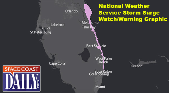

CLICK HERE FOR BREVARD COUNTY NEWS


