NWS: Tornado Warning Issued For Sebastian, Micco, Grant-Valkaria Until 6:30 PM EDT
By Space Coast Daily // September 3, 2019
HURRICANE DORIAN TORNADO WARNING
Tornado Warning including Sebastian FL, Micco FL, Grant-Valkaria FL until 6:30 PM EDT pic.twitter.com/ldFAW5jGom
— NWS Melbourne (@NWSMelbourne) September 3, 2019
SPACE COAST DAILY TV HURRICANE DORIAN 5 P.M. TUESDAY UPDATE: Space Daily’s Chris Bonanno discusses the latest report by the National Hurricane Center on Hurricane Dorian as of 5 p.m. Tuesday.

NATIONAL HURRICANE CENTER 5 P.M. UPDATE:
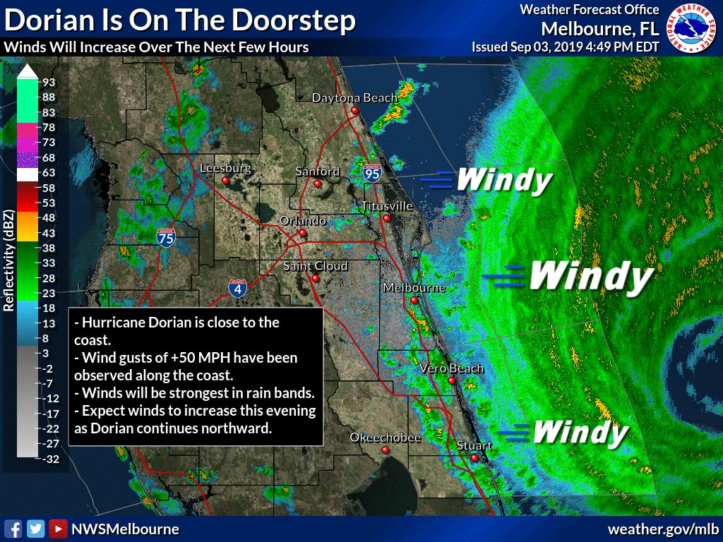
BREVARD COUNTY, FLORIDA – The National Hurricane Center reported at 5 p.m. Tuesday that Hurricane Dorian is a CAT 2 storm with 110 mile-per-hour winds and moving north-northwest at 6 miles per hour.
Rain bands will increase in frequency as the center of Hurricane Dorian makes its closet approach to Brevard County tonight into tomorrow morning.
These bands will contain wind gusts of 40-60 mph and heavy rainfall.
Observations from this afternoon show that the strongest winds are along the barrier islands from Cape Canaveral south through Jupiter Inlet.
Expect winds to increase over the next few hours to 30 to 45 mph, with gusts over 50 mph, especially along the coast.
The National Weather Service recorded wind gusts of 60 mph northeast of Barefoot Bay and a gust of 58 mph near Port Canaveral on Thursday afternoon.
Expect a storm surge of up to 4 feet above normal high tide tonight through Wednesday.
STAY TUNED TO SPACE COAST DAILY FOR UPDATES
 Related Story:
WATCH: Follow Hurricane Dorian On National Weather Service Radar as it Approaches Brevard County


The National Weather Service in Melbourne forecasts predicts new rainfall amounts between three quarters and one inch possible on Tuesday. Here’s the NWS weather forecast for Brevard county through Sunday:
• On Tuesday night, tropical storm conditions are expected, with hurricane conditions possible with new rainfall amounts between 1 and 2 inches possible.
• Wednesday: Tropical storm conditions expected, with hurricane conditions possible. Showers and possibly a thunderstorm. Some of the storms could produce heavy rain. High near 90. Chance of precipitation is 80%. New rainfall amounts between 1 and 2 inches possible.
• Wednesday Night: Tropical storm conditions possible, with hurricane conditions also possible. A 20 percent chance of showers. Cloudy, then gradually becoming partly cloudy, with a low around 74.
• Thursday: Mostly sunny and hot, with a high near 95. West southwest wind around 15 mph, with gusts as high as 20 mph.
• Thursday Night: Mostly clear, with a low around 76. West southwest wind 10 to 15 mph.
• Friday: Sunny, with a high near 92. West southwest wind around 10 mph.
• Friday Night: Mostly clear, with a low around 75. West wind 5 to 10 mph.
• Saturday: A 20 percent chance of showers and thunderstorms. Sunny, with a high near 90. West southwest wind 5 to 10 mph.
• Saturday Night: Mostly clear, with a low around 75. South southeast wind 5 to 10 mph.
• Sunday: A 20 percent chance of showers and thunderstorms. Sunny, with a high near 91. South wind around 5 mph.
Sunday Night: Partly cloudy, with a low around 77. South wind 5 to 10 mph.
STAY TUNED TO SPACE COAST DAILY FOR UPDATES
 Related Story:
Brevard Sheriff Wayne Ivey Commends Team Members, Volunteers Working in Space Coast Evacuation Shelters

NATIONAL HURRICANE CENTER: Hurricane Dorian is now Category 2 storm moving slowly at 2 miles per hour to the north-northwest. (NWS image)
CLICK HERE FOR BREVARD COUNTY NEWS


