Tropical Storm Isaias Moves Slowly Towards Florida, Expected to Impact Brevard County by Sunday Night
By Space Coast Daily // August 2, 2020
HURRICANE Isaias COVERAGE
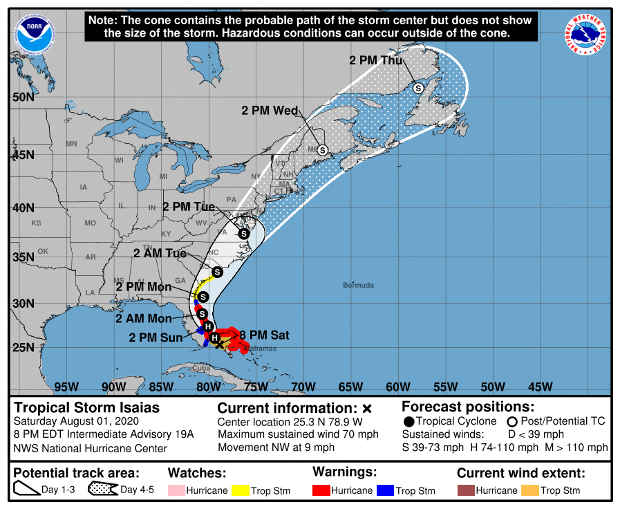

BREVARD COUNTY, FLORIDA – Tropical Storm Isaias is slowly beginning to approach southeast Florida late Saturday, heading into Sunday early morning.
The latest report by NHC shows Tropical Storm Isaias is registering 70 mph max sustained winds and moving to the northwest at 9 mph.
Experts at the National Hurricane Center mention the possibility of Isaias regaining strength early Sunday morning and could return with hurricane strength early Sunday by the time it impacts southeast Florida. The system is expected to weaken again beginning Sunday night when it makes its way up the east coast of Florida, including Brevard County.
Isaias is projected to impact Brevard County by late Sunday night.
Max sustained winds are projected to be 65-70 mph by the time it reaches Brevard County.
“A general northwestward motion with some decrease in forward speed is expected for the next day or so, followed by a north-northwestward motion by late Sunday,” said NHC in the latest report. “A turn toward the north and north-northeast is anticipated on Monday and Tuesday with an increase in forward speed.”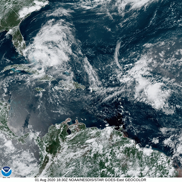
Furthermore, tropical-storm-force winds extend outward up to 115 miles from the center of Isaias.
Brevard County still remains under a Hurricane Warning.
Brevard County Sheriff Wayne Ivey announced on Saturday that there are no mandatory evacuations in Brevard County.
Local state of emergency has been issued for Brevard County.
In Brevard County, experts are projecting storm surge to be between 2-4 feet.
Also, Brevard County is projected to see between 2-4 inches rainfall accumulation.
Brevard County could see 75 mph max sustained winds by late Sunday night, heading into early Monday morning.
The center of Isaias moved over Andros Island in the Northwest Bahamas on Saturday where 69 mph wind gust was measured by the U.S. Navy. The system is continuing to impact the northern Bahamas with strong thunderstorms and dumping a considerable amount of rainfall on the Grand Bahama.
Earlier today, Gov. Ron DeSantis announced on Saturday that President Trump has approved his request for a pre-landfall emergency declaration for counties impacted by Isaias, including Brevard County.
“President Donald Trump has approved my request for a pre-landfall emergency declaration for the counties in the path of Hurricane Isaias. This will help our state respond quickly to any impacts from the storm,” said Gov. DeSantis.
WATCH LIVE: Beach Cameras Capture Footage of Isaias’ Arrival in Florida
Marine Zone Forecast (11 Miles SE from Port Canaveral)*
Tonight – tropical storm conditions expected with hurricane conditions possible. Northeast winds 17-23 mph becoming east 28 mph to 34 mph with gusts to around 46 mph after midnight. Seas 10 feet with a dominant period 9 seconds building to 15 feet with a dominant period 9 seconds after midnight. Very rough on the intracoastal waters. Scattered showers in the evening. Isolated thunderstorms. Numerous showers after midnight.
Sunday – hurricane conditions expected. Northeast winds 46-51 mph with gusts to around 63 mph increasing to 63-74 mph. Extremely rough on the intracoastal waters. Widespread showers in the morning. Isolated thunderstorms. Periods of rain in the afternoon.
Sunday Night – hurricane conditions expected. Southeast winds 63-74 mph becoming south 57 to 69 mph after midnight. Extremely rough on the intracoastal waters. Numerous showers and isolated thunderstorms.
*Brought to you by National Weather Service of Melbourne
CLICK HERE FOR BREVARD COUNTY NEWS


