Ian Now a Category 1 Hurricane, Hurricane Watch Issued for Tampa
By Space Coast Daily // September 26, 2022
Report brought to you by Gorilla Roofing
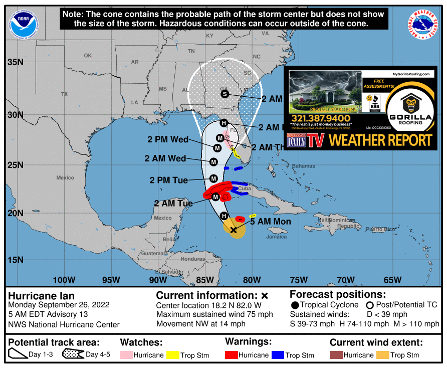
BREVARD COUNTY, FLORIDA – Hurricane Ian has now formed into a category 1 hurricane in the Atlantic, according to National Hurricane Center.
Ian is moving toward the northwest near 14 mph.
A turn toward the north-northwest is expected later today, followed by a northward motion on Tuesday with a slightly slower forward speed. A turn toward the north-northeast is forecast on Tuesday night or early Wednesday. The center of Ian is expected to pass near or west of the Cayman Islands today, and near or over western Cuba tonight and early Tuesday.
Ian will then emerge over the southeastern Gulf of Mexico on Tuesday, pass west of the Florida Keys late Tuesday, and approach the west coast of Florida on Wednesday.
Maximum sustained winds are near 75 mph with higher gusts. Rapid strengthening is expected during the next day or so, and Ian is forecast to become a major hurricane tonight when it is near western Cuba.
Hurricane-force winds extend outward up to 15 miles from the center and tropical-storm-force winds extend outward up to 90
miles.
SUMMARY OF WATCHES AND WARNINGS IN EFFECT:
A Hurricane Warning is in effect for…
* Grand Cayman
* Cuban provinces of Isla de Juventud, Pinar del Rio, and Artemisa
A Tropical Storm Warning is in effect for…
* Cuban provinces of La Habana, Mayabeque, and Matanzas
* Lower Florida Keys from Seven Mile Bridge westward to Key West
* Dry Tortugas
A Storm Surge Watch is in effect for…
* Florida Keys from the Card Sound Bridge westward to Key West
* Dry Tortugas
* Florida Bay
* Anclote River southward to the Card Sound Bridge
* Tampa Bay
A Hurricane Watch is in effect for…
* Englewood to the Anclote River, including Tampa Bay
A Tropical Storm Watch is in effect for…
* Little Cayman and Cayman Brac
* Englewood southward to Chokoloskee


