National Hurricane Center Monitors Tropical Storm Dorian, Moves Closer To Windward Islands
By Space Coast Daily // August 25, 2019
ABOVE VIDEO: Space Coast Daily’s Chris Bonanno discusses the newly-formed Tropical Storm Dorian in the Atlantic as announced by the NOAA NWS National Hurricane Center.

BREVARD COUNTY, FLORIDA – National Hurricane Center is continuing to monitor Tropical Storm Dorian, located about 430 miles east from Barbados, according to the Sunday afternoon report by NHC.
The system is moving to the west at 14 mph and carrying 40 mph max sustained winds.
According to the National Hurricane Center, Dorian is expected to turn toward the west-northwest on Monday.
If the system continues on the current forecast track, the center of Dorian is expected to be near the Windward Islands late Monday or early Tuesday.
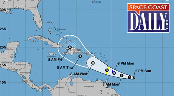
Subsequently, Dorian will move into the eastern Caribbean Sea on Tuesday.
Experts are projecting Dorian will become a category 1 hurricane by Tuesday before it approaches Puerto Rico.
Dorian is expected to produce total rain accumulations of 2 to 4 inches in portions of the Lesser Antilles, with possible isolated maximum amounts of 6 inches.

CLICK HERE FOR BREVARD COUNTY NEWS