National Hurricane Center Monitoring Three Disturbances Spanning Across the Gulf, Atlantic Ocean
By Space Coast Daily // July 20, 2020

BREVARD COUNTY, FLORIDA – National Hurricane Center is currently monitoring three disturbances that span from the Atlantic Ocean to the Gulf of Mexico.
As of Monday morning, two of the three disturbances have a 20-percent chance at cyclone formulation in the next five days.
Currently, each one of the systems is producing rain showers and thunderstorms with ocean temperature conditions becoming more ripe for development as the systems move into warmer waters.
The Atlantic basin has produced six named storms so far this season.
The activity has delivered some of the earliest activity in the past fifty years.
Although, none of the storms have reached hurricane intensity yet this year.
The next storm name will be Gonzalo.
Sea surface temperatures in the Atlantic Ocean have been abnormally warm so far in 2020, which could help fuel storms.
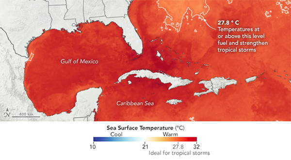
According to NASA’s Earth Observatory, “Warm ocean water evaporates and provides moisture and energy for the lower atmosphere. As water vapor rises and condenses, it releases heat that warms the surrounding air and can promote the growth of storms. Ocean waters typically need to be above 27°C (80°F) for storms to develop. In early July, parts of the Atlantic basin (which includes the Gulf of Mexico and Caribbean) hit temperatures of 30°C (86°F).”
CLICK HERE FOR BREVARD COUNTY NEWS