Category 5 Hurricane Milton Moves Closer to Yucatan Peninsula, Will Impact Florida on Wednesday
By Space Coast Daily // October 7, 2024
stay tuned to Space Coast Daily for Hurricane Milton Updates
WATCH: Live Hurricane Milton update and information with Sheriff Wayne Ivey and Emergency Management Director John Scott from earlier today.

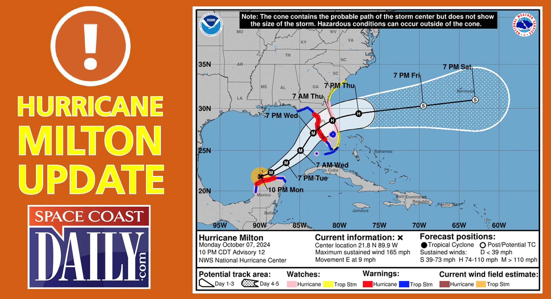
BREVARD COUNTY, FLORIDA – Hurricane Milton continues to barrel towards Florida as a Category 5 Hurricane carrying 165 max sustained winds.
This general motion is expected through tonight followed by a turn toward the east- northeast and northeast on Tuesday and Wednesday.
On the forecast track, the center of Milton is forecast to move near or just north of the Yucatan Peninsula tonight and Tuesday, then cross the eastern Gulf of Mexico and approach the west coast of the Florida Peninsula on Wednesday.
Maximum sustained winds are near 165 mph with higher gusts. Milton is a potentially catastrophic category 5 hurricane on the Saffir-Simpson Hurricane Wind Scale.
While fluctuations in intensity are expected, Milton is forecast to remain an extremely dangerous hurricane through landfall in Florida.
Milton is a potentially catastrophic category 5 hurricane on the Saffir-Simpson Hurricane Wind Scale.
While fluctuations in intensity are expected, Milton is forecast to remain an extremely dangerous hurricane through landfall in Florida.
Hurricane-force winds extend outward up to 30 miles from the center and tropical-storm-force winds extend outward up to 80 miles.
For historical context, Hurricane Wilma is the strongest Atlantic hurricane ever recorded, after reaching an intensity of 882 mbar in October 2005; at the time, this also made Wilma the strongest tropical cyclone worldwide outside of the West Pacific, where seven tropical cyclones have been recorded to intensify to lower pressures.
However, this was later superseded by Hurricane Patricia in 2015 in the east Pacific, which had a pressure reading of 872 mbar.
Preceding Wilma is Hurricane Gilbert, which had also held the record for most intense Atlantic hurricane for 17 years.
The 1935 Labor Day hurricane, with a pressure of 892 mbar, is the third strongest Atlantic hurricane and the strongest documented tropical cyclone prior to 1950. Since the measurements taken during Wilma and Gilbert were documented using dropsonde, this pressure remains the lowest measured over land.
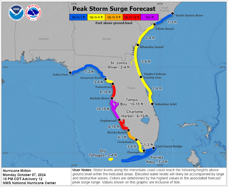
A storm surge will raise water levels by as much as 4 to 6 feet above ground level along the northern coast of the Yucatan Peninsula in areas of onshore winds.
Near the coast, the surge will be accompanied by large and destructive waves.
The combination of a dangerous storm surge and the tide will cause normally dry areas near the coast to be flooded by rising waters moving inland from the shoreline.
The water could reach the following heights above ground somewhere in the indicated areas if the peak surge occurs at the time of high tide…
Anclote River to Englewood…10-15 ft
Tampa Bay…10-15 ft
Englewood to Bonita Beach…6-10 ft
Charlotte Harbor…6-10 ft
Yankeetown to Anclote River…5-10 ft
Bonita Beach to Chokoloskee..4-7 ft
Suwannee River, to Yankeetown,…3-5 ft
Chokoloskee, to Flamingo,…3-5 ft
Flagler/Volusia County Line, FL to Altamaha Sound, GA…3-5 ft
Sebastian Inlet, to Flagler/Volusia County Line,…2-4 ft
Altamaha Sound, GA to Edisto Beach, SC…2-4 ft
Dry Tortugas…2-4 ft
St. Johns River…2-4 ft
The deepest water will occur along the immediate coast near and to the south of the landfall location, where the surge will be accompanied by large and dangerous waves.
Surge-related flooding depends on the relative timing of the surge and the tidal cycle, and can vary greatly over short distances.