Tropical Wave in Eastern Atlantic Shows Increased Signs of Potential Development
By Space Coast Daily // August 5, 2025
Stay tuned to Space Coast Daily for updates!
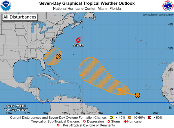 BREVARD COUNTY, FLORIDA – A tropical wave currently situated over the far eastern tropical Atlantic is being monitored for possible development, according to the National Hurricane Center.
The system is producing a broad area of disorganized showers and thunderstorms as it moves west-northwestward across the central tropical and subtropical Atlantic.
While no immediate development is expected, forecasters say environmental conditions could become favorable later this week.
Although the chance of formation through the next 48 hours remains low—near 0 percent—the system has a medium, 50 percent chance of developing into a tropical depression within the next seven days.
The system will have some initial dry air to fend off in its path. It could develop into a depression or storm by this weekend east of the Lesser Antilles
Experts advise that now is the time to make sure your hurricane plan is ready to go, before a storm threatens.
Another disturbance that the National Hurricane Center is monitoring is a weak surface trough located several hundred miles off the southeastern U.S. coast is generating scattered showers and thunderstorms this afternoon.
Forecasters say an area of low pressure is expected to form from this system within the next day or so. Environmental conditions are currently conducive for gradual development, and there is potential for a tropical depression to form by the end of the week or over the weekend.
The system is expected to begin moving slowly westward before turning more northward later this weekend.
The National Hurricane Center gives the system a 10 percent chance of formation over the next 48 hours, and a 40 percent chance of development over the next seven days.
Hurricane season ends on November 30.