National Weather Service in Melbourne Issues Evening ‘Strong Storm’ Risk for East Central Florida
By Space Coast Daily // April 12, 2025
isolated severe thunderstorm cannot be ruled out
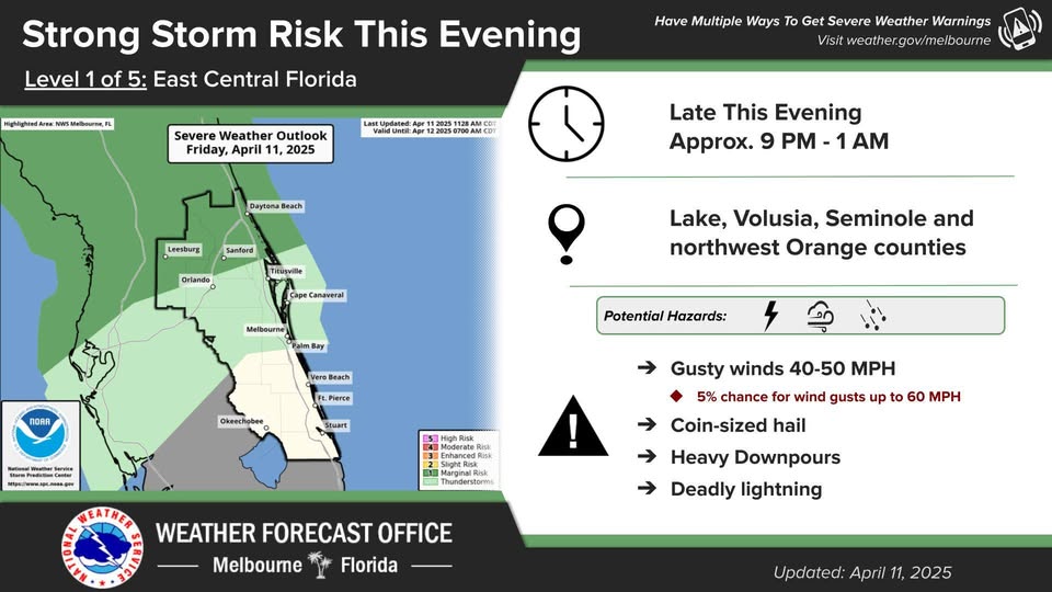
BREVARD COUNTY • FLORIDA — The National Weather Service in Melbourne has issued a Level 1 out of 5 risk for severe weather across parts of East Central Florida this evening, Friday, April 11. Showers and isolated thunderstorms are expected to begin moving into Lake and Volusia counties and progressing toward the I-4 corridor later this evening.
Timing:
Storm activity is expected to develop and intensify by 1 a.m. on April 12
Areas of Concern:
● Lake County
● Volusia County
● Seminole County
● Northwest Orange County (including areas just north of Orlando)
Hazards and Potential Impacts:
● Gusty Winds: Sustained gusts of 40–50 MPH, with a 5% chance for isolated gusts reaching up to 60 MPH.
● Hail: Possibility of coin-sized hail with stronger cells.
● Heavy Downpours: Localized flooding may occur in poor drainage areas.
● Lightning: Expect deadly cloud-to-ground lightning with any stronger storms.
While the overall severe weather threat remains low, an isolated severe thunderstorm cannot be ruled out, especially for areas north of Orlando.
Preparedness Tips:
Residents are encouraged to monitor weather updates throughout the evening and have multiple ways to receive severe weather alerts. Be prepared to take action if warnings are issued for your area.
Stay updated for the latest developments.
 Related Story:
HOT OFF THE PRESS! April 14, 2025 Space Coast Daily News – Brevard County’s Best Newspaper