Strong Thunderstorms to Impact Brevard County Today, Wind Gusts Reach 45-55 MPH
By Space Coast Daily // June 27, 2025
Stay tuned to Space Coast Daily for updates!
BREVARD COUNTY, FLORIDA – Residents across Brevard County should be prepared for the possibility of strong storms this afternoon and evening, according to an updated forecast from the National Weather Service (NWS) in Melbourne.
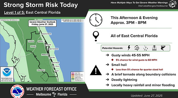
The NWS has placed the region under a Level 1 out of 5 risk for severe weather today, with storms most likely between approximately 3 p.m. and 8 p.m.
Forecasters warn that the main hazards include gusty winds ranging from 45 to 55 mph, with a 5% chance that winds could reach as high as 60 mph in some areas.
Small hail is also possible, though the risk of quarter-sized hail or larger is under 5%.
Additional concerns include deadly lightning, brief tornadoes that may develop along boundary collisions, and locally heavy rainfall which could cause minor flooding in low-lying areas.
Emergency officials urge residents to stay weather-aware, have multiple ways to receive warnings, and avoid outdoor activities during thunderstorms.
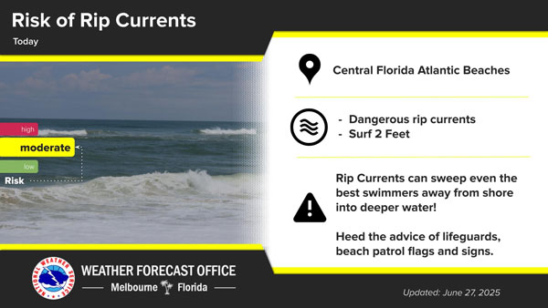
Beachgoers along Central Florida’s Atlantic coastline are urged to exercise caution today, as the National Weather Service (NWS) in Melbourne has issued a moderate risk of rip currents.
According to the NWS advisory, surf conditions are expected to reach around two feet, creating potentially dangerous rip currents capable of pulling even strong swimmers away from shore and into deeper water.
“Rip currents can sweep even the best swimmers away from shore into deeper water,” the warning reads. “Heed the advice of lifeguards, beach patrol flags, and posted signs.”
Visitors are reminded to always swim near a lifeguard and remain vigilant for changing water conditions. The NWS emphasizes that recognizing the signs of rip currents—such as a break in the incoming wave pattern or a channel of churning, foamy water—can be crucial for safety.
The rip current risk is expected to persist throughout the day. Beachgoers are advised to stay updated with local forecasts and warnings before heading to the coast.