Heavy Rain Predicted For Brevard County
By Michael Moore II // May 2, 2013
WEATHER WATCH
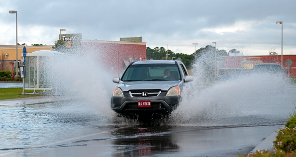
BREVARD COUNTY, FLORIDA – Heavy rain fell overnight in parts of Brevard County with radar estimates of nearly 3 inches in Cape Canaveral and Southern Palm Bay in the past 24 hours. With heavy rain in the forecast again each day through Saturday we quickly switch from brush fire conditions to concerns about flooding.

There are currently no watches or warnings for East Central Florida, although a flood watch may be posted later today or tomorrow if conditions warrant.
SLOW STORMS CAN DUMP LOTS OF RAIN IN SHORT PERIOD
The National Weather Service in Melbourne has forecasted a 70% chance of heavy rain today and tomorrow with rain chances falling to 50% on Saturday. One concern today and tomorrow is weak steering aloft, which cause very slow moving storms. The slow and erratically moving storms can dump several of inches of rain in a small area in a very short period of time.
SLOW DOWN ON SLICK ROADS
It only takes 18 inches of water to lift your car or SUV. Once your vehicle becomes buoyant; the water will easily push it sideways. If you are driving and the road has water over it, you need to remember this simple saying: “Turn Around – Don’t Drown.”
Never drive on a road with water covering it and never drive around barriers blocking a flooded road. Drivers are urged to use caution during heavy rain. Disengage your cruise control and reduce your speed to avoid hydroplaning.
Remember to monitor your NOAA Weather Radio for vital weather related information and stay with Space Coast Daily for continuing severe weather updates.
Forecast For Thursday, May 2, 2013
 Thursday, 2
Precipitation
Descriptive Forecast
| Mostly cloudy with a chance of a thunderstorm and a chance of rain, then thunderstorms and rain showers in the afternoon. High of 81F. Winds from the North at 5 to 15 mph. Chance of rain 70% with rainfall amounts near 0.4 in. possible. |
| Mostly cloudy with a chance of a thunderstorm and a chance of rain. Low of 70F. Winds from the East at 5 to 15 mph. Chance of rain 50% with rainfall amounts near 0.4 in. possible. |
| Hourly Forecast | 6AM | 12 Noon | 6PM | 12 Midnight |
|---|---|---|---|---|
| Temp. | Dew Point | 70 | 64 | 77 | 64 | 77 | 64 | 73 | 64 |
| Wind | 4 mph ENE | 8 mph West | 13 mph East | 9 mph East |
| Humidity | 79% | 66% | 64% | 73% |
| Chance of Precip. | 50% | 70% | 70% | 50% |
| Cloud Cover | 90% | 85% | 85% | 88% |
| Conditions | Chance of Rain | Chance of a Thunderstorm | Thunderstorm | Chance of a Thunderstorm |
| Sunrise & Sunset |
6:41 AM
7:58 PM
|
|||