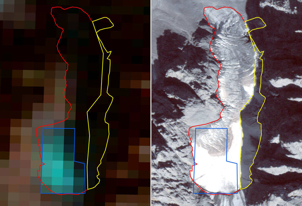
A comparison of images of a small glacier in the Kaçkar Mountains in northeastern Turkey: the one on the left was taken by Landsat-5 on September 19, 2011, and the one on the right was captured by the commercial satellite WorldView-2 on September 8, 2011. The blue line shows the margins of the glacier as seen by Landsat – the delineated margins correspond to 0.07 square miles (0.2 square kilometers) of glacier ice. The WorldView-2 image reveal areas of ice in the shadows cast by nearby peaks or obscured by debris deposits over glacier ice: using this data, the researchers were able to map 0.28 square miles (0.74 square kilometers) of sunlit glacier ice, plus 0.07 square miles (0.2 square kilometers) of ice in the shadows (delineated in yellow). (NASA Image)
NASA – A small glacier crowning one of the Kaçkar Mountains in eastern Turkey appears as a blurry cluster of blue pixels in an image captured in September 2011 by NASA’s and U.S. Geological Survey’s Landsat 5 satellite.
A view of the same glacier, taken by the commercial satellite WorldView-2 in the same month, reveals areas of ice that escaped Landsat, hidden in the shadows cast by nearby peaks or obscured by debris deposits.
These are just two of the images analyzed in a new study by researchers from NASA and Turkey’s Ege University. The team used satellite scenes from research and commercial satellites to map changes in the extent of Turkey’s 14 glaciers from the 1970s to the present.
Two views of Gedik Glacier, a small glacier in the Mercan Mountains in central Turkey. On the left, an image captured by Landsat 5 on September 10, 2011. On the right, a scene taken by the commercial satellite WorldView-2 on September 13, 2011. Landsat-5 data mapped 0.02 square miles (0.06 square kilometers) of glacier ice while WorldView-2 data mapped 0.02 square miles (0.06 square kilometers) of sunlit ice, plus an area of glacier ice in the shadow (delineated in yellow) amounting to 0.015 square miles (0.04 square kilometers). “This shows that Landsat data give comparable mapping accuracies for the sunlit portions of small glaciers while underestimating the total glacier area by 40% due to shadows,” said Compton Tucker, one of the authors of the study. “This disparity is more pronounced for smaller glaciers and less so for larger glaciers.” (NASA Image)
Most of Turkey’s glaciers are small, less than one square mile in area.
The study, published on June 15 in the journal Remote Sensing of Environment, showed that the area of glaciers in Turkey shrunk by more than half in four decades: they went from 9.6 square miles (25 square kilometers) in the 1970s to 4.2 square miles (10.85 square kilometers) in 2013.
During this period, five glaciers disappeared completely. The scientists attributed the recession of Turkey’s glaciers to increasing summer minimum temperatures.
There were no changes in precipitation nor in cloud cover in Turkey’s glacier regions from the 1970s to the present.
This is the first attempt to map the small glaciers of a whole country using a combination of imagery from government and commercial satellites.
A small glacier crowning one of the Kaçkar Mountains in eastern Turkey appears as a blurry cluster of blue pixels in an image captured in September 2011 by NASA’s and U.S. Geological Survey’s Landsat 5 satellite. (NASA Image)
In total, the researchers analyzed 72 Landsat images and 41 commercial satellite images (from IKONOS, Quickbird-2, GeoEye-1 and WorldView-1 and -2), in addition to five scenes captured by the ASTER instrument on NASA’s Terra spacecraft.
The images from the satellites of the Landsat program have a spatial resolution (the area of Earth’s surface contained in each pixel of a satellite image) that varies from 196 feet (60 meters) per pixel for the first three Landsat missions —the first one launched in 1972— to up to 49 feet (15 meters) per pixel for Landsat 8, launched in 2013.
In comparison, Digital Globe commercial satellites offer much sharper views: they can “zoom in” as much as 16 inches (40 centimeters) per pixel. The availability of commercial satellite images dates back to 2000, while the Landsat satellite series started collecting information in 1972.
The longer Landsat record allowed the researchers to reconstruct the extension of Turkey’s glaciers at five time periods between the 1970s and 2013, while the higher resolution of the commercial satellite data let them delineate the current margins of the glaciers more precisely.
WorldView-2’s 16-inch spatial resolution enabled the researchers to find ice camouflaged by debris, by spotting striations in the in the dirt-blanketed glacier sections created by the movement of the underlying ice.
The commercial satellites’ higher radiometric resolution (capability to discriminate differences in brightness) provided the ability to map glacier ice hidden in shadows.
The scientists did not always find more glacier ice in the commercial satellite images: for several Turkish glaciers, they also identified areas where seasonal snow had previously been confused for ice.
Compton Tucker
“The commercial satellite data’s higher spatial detail and higher radiometric resolution are like being able to see in dark,” said Compton Tucker, one of the authors of the study and an Earth scientist at NASA’s Goddard Space Flight Center in Greenbelt, Maryland.
“Landsat data, with their systematic mapping of large areas, told us where to look in greater detail. Without Landsat’s long record, studies like ours would be impossible to undertake, because we don’t have a time machine to go back to the 1970s and 1980s and see how Turkey’s glaciers were doing then,” Tucker said.
“Using Landsat and commercial satellite data together, we can map glaciers with high accuracy. It’s a powerful combination for studying the Earth from space.”
The commercial satellites’ ability to spot ice obscured by shadows would be particularly useful for mapping other glaciers in mountainous terrain, such as the Himalayas and the Andes, Tucker said.