Hurricane Nate Expected To Become Cat. 2 By Landfall, Set To Impact SE LA., Alabama/Florida Border Tonight
By Space Coast Daily // October 7, 2017
ABOVE VIDEO: Fast-moving Hurricane Nate likely to hit land as category 2. (Fox News Video)
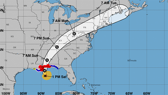
BREVARD COUNTY, FLORIDA – National Hurricane Center is expected to upgrade Hurricane Nate to a Category 2 by landfall tonight after the latest report shows an increase in max sustained winds at 90 mph.
Nate is moving rapidly toward the north-northwest near 25 mph.
On the forecast track, the center of Nate will approach the mouth of the Mississippi during the next several hours and will make landfall along the central U.S. Gulf Coast tonight.
Reports from an Air Force Reserve Hurricane Hunter aircraft indicate that maximum sustained winds are near 90 mph (150 km/h) with higher gusts.
The Mouth of the Mississippi River to the Mississippi/Alabama border is expected to see 7 to 11 feet storm surge. While the Mississippi/Alabama border to the Alabama/Florida border, including Mobile Bay, could see a 6 to 9 feet storm surge.