Hurricane Florence Weakens To Category 2, Record Storm Surge Bound For Carolinas
By Space Coast Daily // September 13, 2018
ABOVE VIDEO: NHC director Ken Graham with Wednesday report on hurricane Florence.

BREVARD COUNTY, FLORIDA – National Hurricane Center’s latest report shows Hurricane Florence has weakened to a Category 2 hurricane with 110 mph max sustained winds.
Florence is moving toward the northwest around 17 mph and is expected to make landfall on Carolinas late Thursday night into early Friday morning.
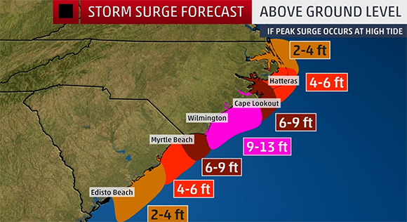
The biggest threat about Florence is the record storm surge expected to hit some areas of the Carolinas which could see as much 13-foot storm surge.
“This is a life-threatening situation,” said the National Hurricane Center.
“Persons located within these areas should take all necessary actions to protect life and property from rising water and the potential for other dangerous conditions.”

Another concern about Florence is the rainfall.
Coastal North Carolina is expected to see 20-30 inches of rain with some areas receiving as much 40 inches of rain.
“Hurricane-force winds extend outward up to 80 miles from the center and tropical-storm-force winds extend outward up to 195 miles,” said the National Hurricane Center.
Evacuation orders have been enacted for portions of South Carolina and North Carolina.
#HurricaneFlorence https://t.co/mP7icn0Yzl pic.twitter.com/jOdKT02rbH
— Donald J. Trump (@realDonaldTrump) September 12, 2018
RESIDENTS MUST EVACUATE FROM THE FOLLOWING ZONES DUE TO #HURRICANEFLORENCE: HORRY & GEORGETOWN EVACUATION ZONES A, B, C; CHARLESTON, DORCHESTER & BERKELEY COUNTY EVACUATION ZONES A, B, C, D, E, F, G,H, & I; ALONG WITH EDISTO BEACH #SCTWEETS #alert
— SCEMD (@SCEMD) September 13, 2018
The President reinforced this is a dangerous storm, and everyone in evacuation areas should follow the advice of Governor McMaster to evacuate while there is still time.
— Lindsey Graham (@LindseyGrahamSC) September 12, 2018
Governor Cooper in Kinston today: “We want to continue to send the message that this monster of a storm is not one to ride out.” pic.twitter.com/osAmqC0lIC
— Governor Roy Cooper (@NC_Governor) September 12, 2018
If you are under an evacuation order and you haven’t left yet, the time to leave is now. You could be putting your life and the lives of first responders in danger. pic.twitter.com/BuGlm5lPsS
— Governor Roy Cooper (@NC_Governor) September 12, 2018
It is imperative that everyone follow local evacuation orders. This storm is extremely dangerous. Be SAFE! #HurricaneFlorence https://t.co/94Ue4e26PD pic.twitter.com/KvF54CwomW
— Donald J. Trump (@realDonaldTrump) September 12, 2018
CLICK HERE FOR BREVARD COUNTY NEWS