HURRICANE DORIAN 5 A.M. NHC UPDATE: Storm Continues to Track Off Brevard Coast, Space Coast Under Hurricane Warning
By Space Coast Daily // September 2, 2019
BREVARD COUNTY UNDER HURRICANE WARNING
SPACE COAST DAILY TV HURRICANE DORIAN 11 P.M. SUNDAY UPDATE: Space Daily’s Chris Bonanno discusses the latest report by the National Hurricane Center on Hurricane Dorian as of 11 p.m. Sunday.

NHC 5 A.M. UPDATE:
BREVARD COUNTY, FLORIDA – The National Hurrican Center reported at 5 a.m. Sunday that Hurricane Dorian’s forecast path continues to track offshore of Brevard County and predicts the center of the storm will be just east of the Space Coast Tuesday evening.
Hurricane Dorian, with nearly unprecedented strength, struck the northern Bahamas as a catastrophic Category 5 storm Sunday, as hundreds hunkered down in schools, churches and shelters.
The 185 mph winds have made it the second-strongest storm in the Atlantic Ocean since 1950.
Reports show maximum sustained winds are now 165 mph with wind gusts reaching 165 mph.
Brevard County is now under a Hurricane Warning.
 Related Story:
Hurricane Dorian Batters Bahamas With 200 MPH Winds; Homes Destroyed, Power Lines Down
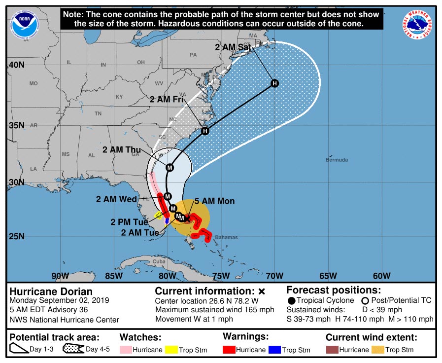
Steering currents have weakened, and Dorian has almost come to a standstill over eastern Grand Bahama Island, with an initial motion of 270/1 kt.
The mid-tropospheric high to the north of the hurricane that had been steering Dorian westward has collapsed. Global models indicate that, in a couple of days, a weakness in the ridge will develop along 75W-80W. This would likely cause Dorian to move northwestward to northward toward and through this weakness.
Later in the forecast period, the system is expected to accelerate northeastward on the southern side of a broad mid-tropospheric trough.
The official track forecast is very close to the previous one and to the corrected dynamical model consensus, HCCA.
Although the official forecast does not show Dorian making landfall along the Florida east coast, it is still possible for the hurricane to deviate from this forecast, and move very near or over the coast.
Users are reminded not to focus on the exact forecast track.
 Related Story:
NWS: Western Rain Bands from Hurricane Dorian Will Begin to Impact Space Coast on Monday
The hurricane is then expected to track near the Georgia and Carolina coasts late this week. This forecast is in best agreement with the various consensus models, which typically have the lowest errors.
It is once again emphasized that although the official track forecast does not show landfall, users should not focus on the exact track. A small deviation to the left of the track could bring the intense core of the hurricane and its dangerous winds closer to or onto the Florida coast.
 Related Story:
Hurricane Shelters Now Open in Brevard, Evacuation Order Went into Effective at 8 a.m. Today
Key Messages:
• Life-threatening storm surges and dangerous hurricane-force winds are expected along portions of the Florida east coast through mid-week, and storm surge and hurricane warnings are in effect. Only a slight deviation to the left of the official forecast would bring the core of Dorian near or over the Florida east coast. Residents should listen to advice given by local emergency officials.
• Heavy rains, capable of producing life-threatening flash floods, are expected over northern portions of the Bahamas and coastal sections of the southeast and lower mid-Atlantic regions of the United States through late this week.
• A Storm Surge Watch is in effect for North of Deerfield Beach to the Volusia/Brevard County Line.
A Storm Surge Watch means there is a possibility of life-threatening inundation, from rising water moving inland from the coastline, in the indicated locations during the next 48 hours.
For a depiction of areas at risk, please see the National Weather Service Storm Surge Watch/Warning Graphic, See below: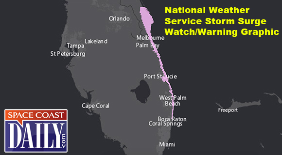
Hurricane-force winds extend outward up to 45 miles from the center and tropical-storm-force winds extend outward up to 140 miles.
Hurricane conditions are possible within the hurricane watch area in Florida by late Monday or early Tuesday.
The historic mark ties the 1935 Labor Day Hurricane, which hit the Florida Keys, as the strongest landfalling hurricane in the Atlantic basin.
After passing through the Bahamas, Hurricane Dorian will begin to make a turn to the north around Monday afternoon. This rainfall may cause life-threatening flash floods, according to the National Hurricane Center.

Dorian’s Forecast Timing – Presented by Weather.com
Monday: Dorian will still be hammering the northwest Bahamas as it crawls slowly. Bands of rain, strong winds may affect parts of Florida. Tropical-storm-force winds are expected in the tropical storm warning area of eastern Florida. How strong the winds will depend on how close the center of Dorian is to the Florida coast, which is still uncertain at this time. Battering waves, coastal flooding and beach erosion will increase along the southeast coast of Florida.
Tuesday: Dorian will still be hammering the northwest Bahamas, but conditions, there may slowly improve by night. Bands of rain, strong winds will still affect parts of Florida. Tropical-storm-force winds are expected in the tropical storm warning area of eastern Florida. We cannot rule out the potential for hurricane-force winds, depending on how close the center tracks to the coast. Coastal flooding and beach erosion will spread north along the Florida coast.
Wednesday-Thursday: Dorian is expected to move north, then northeast near the coasts of northeast Florida, Georgia, South Carolina and North Carolina. The exact track is very uncertain, ranging from a track far enough offshore to keep hurricane-force winds away from land, to a landfall anywhere in this zone. Storm surge flooding, damaging winds and flooding rain are all possible in these areas.
Friday-Saturday: Dorian is then expected to race off the Northeast Seaboard, but could track close enough to bring rain and some wind to the Virginia Tidewater, Nantucket, Martha’s Vineyard and Cape Cod, before it heads toward the Canadian Maritimes by next weekend.

CLICK HERE FOR BREVARD COUNTY NEWS