Haulover Canal Among Most Historic Sites on Merritt Island, Used as Early as 1606 By Indians, Explorers
By Michael Knight // June 6, 2020
Used as Early as 1606 By Indians, Spanish Explorers


BREVARD COUNTY • MERRITT ISLAND, FLORIDA – One of the most historic sites on Merritt Island is not a town, but a canal.
Early Indians, explorers and settlers called the narrow strip of land “The Haulover,” because canoes and small boats were hauled over the strip of land as they traveled between the Mosquito Lagoon and the Indian River.
The Spaniards used the area as early as 1606 and slid boats over the ground covered with Mulberry tree bark. Early settlers used rollers and skids to drag schooners across.
One incentive in constructing a canal was the establishment of a mail run from New Smyrna to Miami in 1850. Since there was no canal at that time, two boats were required, one on each side of the isthmus of land.
In 1852, the federal government contracted Dr. G. E. Hawes to construct the canal for $5,000.
The canal was a mile north of Douglas Dummitt’s summer house and was dug by hand through Coquina rock by slaves of a local citrus grower. It was straight, about 500 yards long, 3 feet deep and 10 to 14 feet wide.
Each end was marked by two stakes in the water a half-mile from the shore. A footpath leads along the canal, on the tip of the bank, which is in the middle of the ridge, 10 feet high and sparsely covered with cedars. The “Umbrella Tree” marked the south end of the canal.
 Related Story:
HOT OFF THE PRESS! June 1, 2020 Space Coast Daily News – Brevard County’s Best Newspaper
Within 15 years, the canal proved to be inadequate because of the shoals that accumulated at each end and the strong current. It was so narrow and shallow in places that only small boats could navigate it.
Waters of the Indian River were usually two or three feet higher than the Mosquito Lagoon, and with a strong current, it made it difficult for vessels trying to move against it. Some slumping occurred and bigger boats had to be pulled through or “hauled over” on rollers.
In 1879 citizens of Titusville and others along the river formed a company for the purpose of widening the Haulover Canal, but they could not raise the necessary funds.
The legislature in 1879 chartered the Haulover Tram Railroad Company headed by Phineas D. Wesson of Titusville to construct a railroad that would transport river craft from the Mosquito Lagoon to the Indian River to facilitate transportation.
Although this firm would have been eligible for land grants, it was never able to begin work or raise the private funds for the opening of the waterway, and citizens turned to Congress. J. F. LeBaron, an engineer who lived in Titusville reported to Congress in 1881 that improvement of the Haulover Canal could be made more adequate to meet the needs for approximately $66,000.

No action was taken by Congress on the LeBaron report because the Florida Coast Line Canal & Transportation Company was granted a state charter in August 1881 to build and maintain an Intracoastal Waterway along the same route.
Steamboat and cargo ships had used the original Haulover Canal as an important transportation link in Florida’s inland waterway system for over 30 years until it was abandoned in 1884.
The Florida Coast Line Canal & Transportation Company took over the operation in 1885 and dug the New Haulover Canal. The new canal was constructed deeper and wider and less than a mile north of the old canal. It opened in 1887-88.
The area around the canal was often referred to as “Haulover,” and the Haulover Post Office was opened in 1885. In 1886, Charles H. Nauman became the postmaster of Haulover and subsequently became a grove owner and county leader.
The post office had previously been opened and closed several times, but in 1886 it enjoyed daily mail. J. D. Vann ran a store and restaurant there for some time. In 1893 the Florida East Coast Railroad was extended from Daytona to Rockledge, ending the steamboat era on the Indian River.

On December 20, 1915, at 12 noon, fees began to be charged for vessels using the Haulover Canal. The following schedule lists the rates:
■ Pleasure boats and houseboats over 40 feet, 10¢ per foot
■ Pleasure boats and houseboats under 40 feet, 8¢ per foot
■ Freight and passenger boats, 5¢ per foot and 5% on gross rates from freight and passengers
■ Barges and lighters in tow: loaded..8¢ per foot and 5% on freight, 8¢ per foot on tug
■ Barges and lighters in tow: unloaded, 5¢ per foot, 5¢ per foot on tug
■ Fish boats, 3¢ per foot
The New Haulover Canal continued to be used and the Intercoastal Waterway incorporated the canal as a federal project in 1927 and was maintained and completed by the U.S. Army Corps of Engineers in the 1930s. Since then, little change has been made to the canal with the exception of making the canal wider and deeper and adding a basin for launching boats.
There were no hard surface roads for travelers or a bridge over the Haulover Canal. In 1921 residents proposed building a bridge over the Haulover Canal and constructing a paved road to Shiloh on the north and Orsino on the south.
The description and proposed location of the road and bridge to be constructed and designated as the “Allenhurst-Shiloh Road” was published in the Star Advocate newspaper dated November 10, 1922, as follows:
“A road designated herein as the “Allenhurst-Shiloh Road” beginning at the north boundary of Brevard County in the town of Shiloh and following the general line of the present county road in a Southeasterly direction crossing the Haulover Canal, and passing through the Dummitt Grove property, and continuing in a general southeasterly direction along the most practicable route to a junction with the Beach Road hereinafter described, a distance of approximately 12 miles, including drawbridge over the Haulover Canal, with suitable approaches, said road to be graded and paved with shell, marl, rock or other suitable hard-surfacing materials. The estimated cost of this road and bridge is twenty-five thousand dollars ($25,000).”
According to another article, the draw-bridge (swing-bridge) over the Haulover Canal was not completed until 1933.
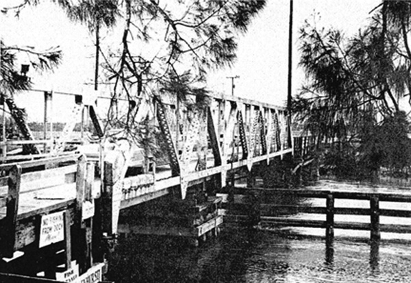
An article in the local newspaper dated August 11, 1964, entitled “Two-Laner Replacement – Haulover Canal bridge coming down” One-lane, Wooden-Floored Landmark Destined to Come Tumbling Down, NASA to replace it with bridge more suitable to space age.”
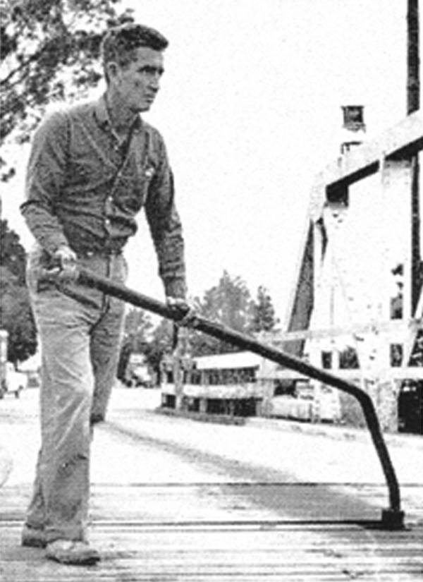
This article talks about the replacement of the old, wooden, manually-operated, hand-crank, bridge over the Haulover Canal with newer, mechanically-operated, two-sided bridge using bridge machinery available in 1964.
It goes on to describe the replacement as, “a new, double-leaf draw-bridge, similar to the ones on the NASA Causeway on the Indian and Banana rivers, will be constructed to replace the hand-crank, single-lane drawbridge over the canal.
Sometime later, NASA replaced the 1964 two-lane draw bridge with another two-lane draw bridge a lot taller than what was there in 1964. The new, taller draw bridge was installed to accommodate larger and taller freight passing under the bridge. That also allowed vessels to pass under the taller draw bridge without requiring manpower to operate the draw bridge.
 Related Story:
BLASTOFF! Crew Dragon, SpaceX Demo-2 Crew Lift Off From Kennedy Space Center, Arrive in Orbit
CLICK HERE FOR BREVARD COUNTY NEWS


