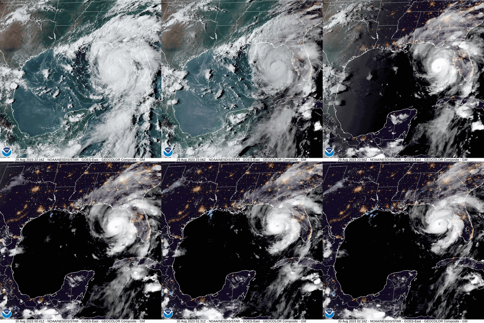
Hurricane Idalia to Become Category 4 Hurricane When It Makes Landfall on Florida’s Gulf Coast: NHC Report
By Space Coast Daily // August 29, 2023
Report brought to you by Gorilla Roofing

 BREVARD COUNTY, FLORIDA – National Hurricane Center has upgraded Idalia to a Category 2 Hurricane on Tuesday as storm prepares to make landfall on Florida Wednesday morning.
Idalia is moving toward the north near 16 mph. A faster motion toward the north and north-northeast is expected through early Wednesday while Idalia approaches the Gulf coast of Florida.
A turn toward the northeast and east-northeast is forecast late Wednesday and Thursday, bringing the center of Idalia near or along the coasts of Georgia and the Carolinas.
Maximum sustained winds have increased to near 110 mph with higher gusts.
Rapid intensification is expected before landfall, and Idalia is forecast to be a major hurricane when it reaches the Gulf coast of Florida Wednesday morning.
Hurricane-force winds extend outward up to 15 miles from the center and tropical-storm-force winds extend outward up to 160 miles.
The combination of a dangerous storm surge and the tide will cause normally dry areas near the coast to be flooded by rising waters moving inland from the shoreline.
The water could reach the following heights above ground somewhere in the indicated areas if the peak surge occurs at the time of high tide…
Aucilla River, FL to Yankeetown, FL…10-15 ft
Yankeetown to Chassahowitzka, FL…7-11 ft
Ochlockonee River, FL to Aucilla River, FL…7-11 ft
Chassahowitzka, FL to Anclote River, FL…6-9 ft
Anclote River, FL to Middle of Longboat Key, FL…4-6 ft
Tampa Bay…4-7 ft
Carrabelle, FL to Ochlockonee River, FL…4-7 ft
Middle of Longboat Key, FL to Englewood, FL…3-5 ft
Englewood, FL to Bonita Beach, FL…2-4 ft
Charlotte Harbor…2-4 ft
Indian Pass, FL to Carrabelle, FL…3-5 ft
Mouth of the St. Mary’s River to South Santee, SC…2-4 ft
Beaufort Inlet to Drum Inlet, NC…2-4 ft
Pamlico and Neuse Rivers…2-4 ft
South of Bonita Beach to Chokoloskee, FL…1-3 ft
South Santee, SC to Beaufort Inlet, NC…1-3 ft
Drum Inlet to Duck, NC…1-3 ft
Chokoloskee, FL to East Cape Sable, FL…1-3 ft
Flagler/Volusia County Line, FL to Mouth of St. Mary’s River…1-3
ft
Indian Pass to Mexico Beach…1 to 3 ft.
Florida Keys…1-2 ft
The deepest water will occur along the immediate coast in areas of onshore winds, where the surge will be accompanied by large and dangerous waves. Surge-related flooding depends on the relative timing of the surge and the tidal cycle, and can vary greatly over short distances.
For information specific to your area, please see products issued by your local National Weather Service forecast office.
Elevated water levels along the southern coast of Pinar del Rio, Cuba will gradually subside today.
A few tornadoes will be possible along the west central Florida coast through tonight. The tornado threat will also spread northward into the Florida Big Bend tonight, and toward southeast Georgia and the coastal Carolinas Wednesday.
Upon Governor DeSantis’ request, the Federal Emergency Management Agency (FEMA) has granted a pre-landfall emergency declaration for Tropical Storm Idalia.
Additionally, the State Emergency Operations Center has activated to Level One in anticipation of potential impacts from the storm.
Governor Ron DeSantis announced that he has directed the suspension of tolls along Florida’s west coast in preparation for Tropical Storm Idalia. By suspending tolls in the impacted area, Floridians and visitors will be better able to quickly and safely evacuate when directed by local officials. Tolls will be waived beginning at 4:00AM on Tuesday, August 29, 2023.
“At my direction, tolls will be suspended throughout the impacted area,” said Governor Ron DeSantis. “Anyone who receives an evacuation order needs to make plans to go to a safe area now. You do not need to leave the state— travel tens of miles, not hundreds of miles. By waiving tolls, we are easing the burden on families in the path of this storm.”
“As Floridians along the west coast of Florida finalize their evacuation plans for Tropical Storm Idalia, we want to ensure there is no barrier to getting their families to a safe location,” said FDOT Secretary Jared W. Perdue, P.E. “The Department is committed to ensuring travelers can get where they need to go as safely and efficiently as possible. Suspending tolls in the greater Tampa Bay region ensures families can head south and east with ease to get out of the storm’s direct path.”
The Florida Department of Transportation (FDOT) and Florida’s Turnpike Enterprise (FTE) will suspend toll collection at 4:00 AM EST on Tuesday, August 29, for a seven-day period, with tolls being reinstated on Tuesday, September 5, at noon.
Facilities included within the suspension include:
Hillsborough County
I-4 Connector
Selmon Expressway (S.R. 618)
Veterans Expressway (S.R. 589)
Suncoast Parkway (S.R. 589)
Citrus, Hernando & Pasco Counties
Suncoast Parkway (S.R. 589)
Lake and Sumter Counties & Portions of Orange County
Turnpike Mainline (I-75 to I-4)
Pinellas County
Pinellas Bayway (S.R. 679)
Sunshine Skyway Bridge (U.S. 19)
FDOT previously issued an Emergency Order to temporarily allow expanded weight and size requirements for vehicles transporting emergency equipment, services, and supplies. Additionally, FDOT has 525 crew members and 210 pieces of equipment ready to deploy following the storm to ensure roadways are safe.
Florida’s 511 Traveler Information System is available for drivers to stay informed about roadway conditions during emergencies. This service is monitored and updated 24/7 by FDOT and includes traffic conditions, road and bridge closures, and other specialized alerts. To use Florida’s 511, visit the website at FL511.com or download the app on both Apple and Android devices.


