National Weather Service Calls for Heat Indices of 100 Degrees and Above for Memorial Day Weekend
By Space Coast Daily // May 25, 2024
peak heat indices in excess of 105 degrees will be possible next week
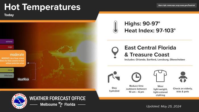
BREVARD COUNTY, FLORIDA – The Memorial Day weather forecast calls for above normal to near record temperatures in the low to upper 90s this weekend and into early next week. A Moderate to Major Heat Risk also exists, with isolated to scattered showers/storms are forecast Saturday (20-40%) and isolated showers/storms (20%) Sunday with mostly to partly sunny skies Monday.
The National Weather Service in Melbourne reports that near record high temperatures over this Memorial Day weekend will pose a “Major Heat Risk,” the third highest risk warning on the Weather Service’s 4-point heat risk scale, just short of the highest risk which is “Extreme.”
Temperatures will rise into the upper 80s to mid 90s this afternoon and the low to upper 90s this weekend with heat index values in the 100-107°F degree range.
The National Weather Service issued an advisory to Space Coast residents to drink plenty of liquids, wear light-weight, light-colored clothing, avoid strenuous outdoor activities, and stay in an air conditioned location a much as you can.
The NWS said Heat Indices of 100 degrees and above are possible this weekend and into the early to middle portion of next week, with peak heat indices in excess of 105 degrees will be possible next week, especially across the interior sections.
Isolated to scattered thunderstorms are forecast through the the weekend and into next week, with moderate risk of rip currents.

The Space Coast Daily Weather Report is brought to you by Gorilla Roofing, Inc., a Florida roofing company you can trust. Located at 550 Gus Hipp Boulevard, Unit 2, in Rockledge, Florida, you can reach Gorilla Roofing by calling 321-613-5158 or email info@mygorillaroofing.com.The Space Coast Daily Weather Report is brought to you by Gorilla Roofing, Inc., a Florida roofing company you can trust.
Thirty years of experience in residential and commercial Space Coast roofing services sets Gorilla Roofing apart from the rest. As a Florida-owned family business, Gorilla Roofing prides itself on quality workmanship and superior customer service experience for every customer.
No matter how big or small the job, Gorilla Roofing, Inc. values your business and guarantees you will be 100% satisfied from start to finish as the Gorilla Roofing team of professionals walks you through the process.
Located at 38 Nevins Court on Merritt Island, Florida, you can reach Gorilla Roofing by calling 321-613-5158 or emailing info@mygorillaroofing.com.
 Related Story:
HOT OFF THE PRESS! May 13, 2024 Space Coast Daily News – Brevard County’s Best Newspaper