Hurricane Milton Regains Strength to Become Extremely Dangerous Category 5 Hurricane
By Space Coast Daily // October 8, 2024
stay tuned to Space Coast Daily for Hurricane Milton Updates
ABOVE VIDEO: Hurricane Milton Update on Tuesday by Brevard County Emergency Management.
BREVARD COUNTY, FLORIDA – Hurricane Milton has regained strength to become a Category 5 Hurricane once again as it churns in the Gulf towards the west coast of Florida.
The Category 5 Hurricane is carrying 165 max sustained winds and moving to the east-northwest at 9 mph.
A Storm Surge Warning has been issued from the Volusia/Brevard County Line northward to the mouth of the St. Mary’s River, including the St. Johns River.
A Hurricane Warning has been issued for the east coast of Florida from the Indian River/St. Lucie County Line northward to Ponte Vedra Beach.
The forecast shows a turn toward the east-northeast and northeast is expected today and Wednesday.
The center of Milton is forecast to move just north of the Yucatan Peninsula today and approach the west coast of the Florida Peninsula on Wednesday. The hurricane is forecast to make landfall in Florida Wednesday night.
Maximum sustained winds are near 150 mph with higher gusts.

Milton is an extremely dangerous category 4 hurricane on the Saffir-Simpson Hurricane Wind Scale. While fluctuations in intensity are expected, Milton is forecast to remain an extremely dangerous hurricane through landfall in Florida.
Hurricane-force winds extend outward up to 30 miles from the center and tropical-storm-force winds extend outward up to 105 miles.
A storm surge will raise water levels by as much as 4 to 6 feet above ground level along the northern coast of the Yucatan Peninsula in areas of onshore winds. Near the coast, the surge will be accompanied by large and destructive waves.
The combination of a dangerous storm surge and the tide will cause normally dry areas near the coast to be flooded by rising waters moving inland from the shoreline. The water could reach the following heights above ground somewhere in the indicated areas if the peak surge occurs at the time of high tide…
Anclote River, FL to Englewood, FL…10-15 ft
Tampa Bay…10-15 ft
Englewood, FL to Bonita Beach, FL…6-10 ft
Charlotte Harbor…6-10 ft
Yankeetown, FL to Anclote River, FL…5-10 ft
Bonita Beach, FL to Chokoloskee, FL…4-7 ft
Suwannee River, FL to Yankeetown, FL…3-5 ft
Chokoloskee, FL to Flamingo, FL…3-5 ft
Volusia/Brevard County Line, FL to Altamaha Sound, GA…3-5 ft
The deepest water will occur along the immediate coast near and to the south of the landfall location, where the surge will be accompanied by large and dangerous waves.
Surge-related flooding depends on the relative timing of the surge and the tidal cycle, and can vary greatly over short distances. For information specific to your area, please see products issued by your local National Weather Service forecast office.
Rainfall amounts of 5 to 12 inches, with localized totals up to 18 inches, are expected across central to northern portions of the Florida Peninsula through Thursday.
This rainfall brings the risk of life-threatening flash, urban and areal flooding along with moderate to major river flooding.
Milton will also produce rainfall totals 2 to 4 inches across the Florida Keys through Thursday. In addition, rainfall amounts of 2
to 4 inches with isolated areas.
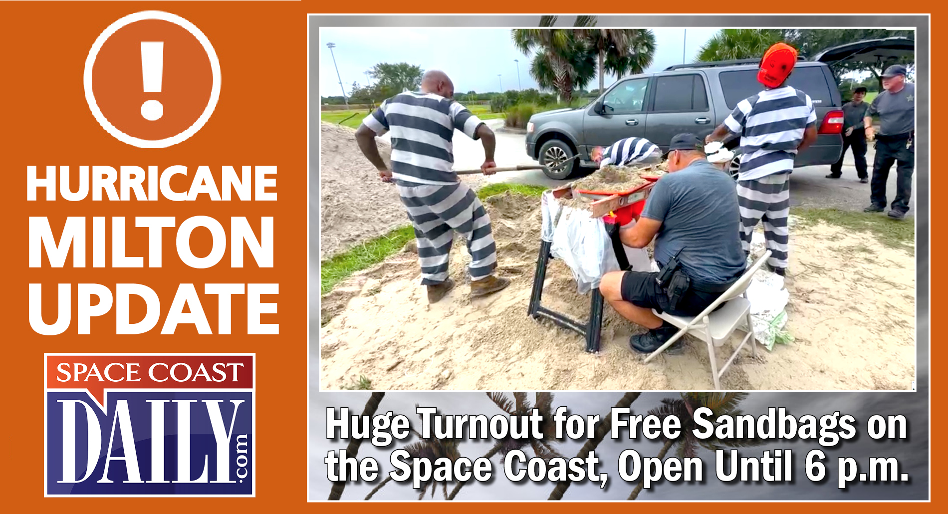
Sandbag Sites open from 8 a.m. to 6 p.m., Tuesday, Oct. 8:
BREVARD COUNTY, FLORIDA – In anticipation of the potential impacts from Hurricane Milton, Brevard County will offer free sandbags for residents beginning 8 a.m. Tuesday.
■ Chain of Lakes Park, 2300 Truman Scarborough Way, Titusville, FL 32796.
■ Mitch Ellington Park, 577 Hall Road, Merritt Island, FL, 32953. Enter from West Hall Road.
■ Wickham Park, 2500 Parkway Dr., Melbourne, FL 32935. Enter using south access from Parkway Dr.
■ Eastern Florida State College-Palm Bay Campus, 250 Community College Parkway SE Palm Bay, 32909
Sand is being provided by Brevard County Public Works and the Brevard County Sheriff’s Office will have supervised inmate work crews filling and loading sandbags for residents.
Residents do not need to bring sandbags, bags are provided and filled by on-site personnel. There is a limit of 10 sandbags per vehicle. Please be aware, lines may be closed earlier than 6 p.m. to ensure a timely closure.
WATCH: Update from sandbag distribution location at Eastern Florida State College’s Palm Bay campus in preparation for Hurricane Milton.
WATCH: Space Coast Daily’s Zach Clark is live from Mitchell Ellington Park in Merritt Island as Brevard Public Works Provides Free Sandbags Today in preparation of Hurricane Milton.

WATCH: Florida Gov. Ron DeSantis provided a Hurricane Milton update Monday morning as Brevard residents all over the county scramble to prepare for Hurricane Milton with miles-long bumper-to-bumper traffic for sandbags. DeSantis has declared a state of emergency for 51 counties ahead of Milton’s landfall on the Florida west coast. On the Space Coast, Peak Sustained Winds of 74 mph, Peak Wind Gusts of 87 mph, and total rainfall of 8 to 12 inches is forecast.
On the Space Coast, Peak Sustained Winds of 74 mph, Peak Wind Gusts of 87 mph, and total rainfall of 8 to 12 inches is forecast on the Space Coast.
Florida Gov. Ron DeSantis provided a Hurricane Milton update Monday morning as Brevard residents all over the county scramble to prepare for Hurricane Milton with miles-long bumper-to-bumper traffic for sandbags.
DeSantis has declared a state of emergency for 51 counties ahead of Milton’s landfall on the Florida west coast. On the Space Coast, Peak Sustained Winds of 74 mph, Peak Wind Gusts of 87 mph, and total rainfall of 8 to 12 inches is forecast.
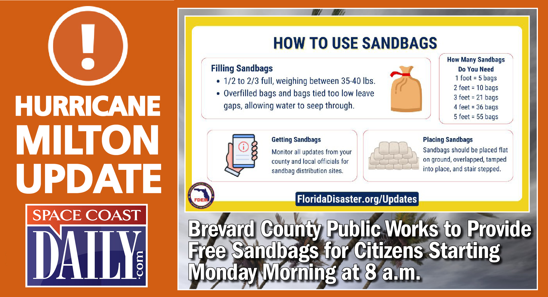
In anticipation of the potential impacts from Hurricane Milton, Brevard County is offering free sandbags for residents, which opened at 8 a.m. Monday, and will close at 6 p.m.
The National Hurricane Center’s 8 a.m. report had Milton as a Category 3 with winds of 125 mph, but just one hour later, Hurricane Hunters reported it grew into a Category 4 storm, with winds of 150 mph.
DeSantis said hurricane watches were in effect for more than 6 million people in west-central Florida and tropical storm watches are in effect for Florida’s Gulf Coast.
“Milton can bring a variety of life-threatening dangers, including an extreme storm surge of 10-15 feet along and near the coast, including in the Tampa Bay area, destructive winds and major flooding to one of the most densely populated parts of Florida, the I-4 corridor, especially from Tampa toward Orlando,” said AccuWeather Chief Meteorologist Jon Porter.
With the National Hurricane Center’s forecast of a major hurricane that will strike the west coast of Florida and will bring hurricane conditions to Brevard County, longtime Central Florida Meteorologist and Space Coast Daily correspondent Danny Treanor offers some sage advice and reminders on how to prepare for a storm. CLICK HERE TO WACH
Sandbag Sites open from 8 a.m. to 6 p.m., Monday, Oct. 7:
■ Chain of Lakes Park, 2300 Truman Scarborough Way, Titusville, FL 32796.
■ Mitch Ellington Park, 577 Hall Road, Merritt Island, FL, 32953. Enter from West Hall Road.
■ Wickham Park, 2500 Parkway Dr., Melbourne, FL 32935. Enter using south access from Parkway Dr.
■ Eastern Florida State College-Palm Bay Campus, 250 Community College Parkway SE Palm Bay, 32909
Sand is being provided by Brevard County Public Works and the Brevard County Sheriff’s Office will have supervised inmate work crews filling and loading sandbags for residents.
Residents do not need to bring sandbags, bags are provided and filled by on-site personnel. There is a limit of 10 sandbags per vehicle. Please be aware, lines may be closed earlier than 6 p.m. to ensure a timely closure.


