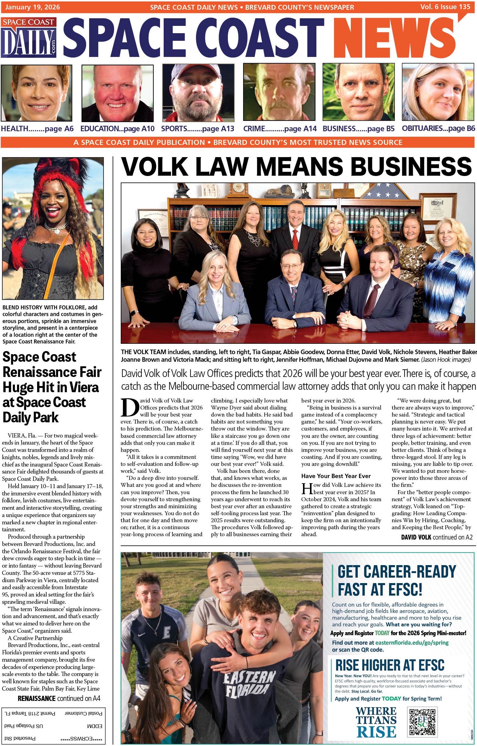
The Bridges That Built the Space Coast: A Look Back at the Hubert H. Humphrey Bridge and Its Historic Predecessors
By Space Coast Daily // September 21, 2025
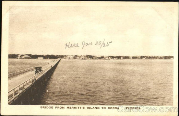
wooden toll bridge was used from 1922 to 1941
BREVARD COUNTY, FLORIDA — Each morning and evening on Florida’s Space Coast, thousands of commuters travel the stretch of State Road 520 between Cocoa and Merritt Island.
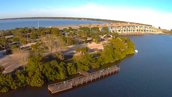
Their route takes them over the sweeping Hubert H. Humphrey Bridge, a high-arching structure that not only connects two communities but also offers travelers stunning panoramic views of the Indian River Lagoon.
For most, the bridge is simply part of a daily routine—an elevated stretch of concrete leading to work, school, or the beaches.
But the story behind the Hubert H. Humphrey Bridge is woven into Brevard County’s history, tracing a century of growth, innovation, and the region’s ties to the U.S. space program.
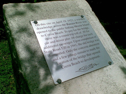
“On this site on April 19, 1923, a wooden drawbridge across the Banana River was opened to the public, linking Merritt Island to Cocoa Beach. To pay for the bridge, there was a round-trip toll of .20 for the car and driver, plus a .04 charge for each additional passenger. Upon completion of State Road 520 in 1941, the old bridge was dismantled. Only the concrete abutment and a few pilings remain to mark the location of the bridge that opened Cocoa Beach to development.”
From Modest Beginnings to a Growing Need
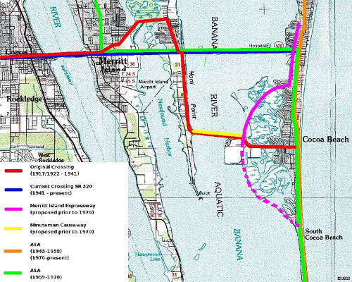
The first bridge across the Indian River at this location was built on May 1, 1917. A modest concrete span, it provided an essential connection between Cocoa and Merritt Island at a time when automobiles were only beginning to dominate transportation.
Though functional, the structure was small by today’s standards. Eventually, remnants of this original bridge were converted into fishing piers—still in use today by anglers seeking redfish, trout, and snook in the Indian River.
As Brevard County grew, so too did its need for stronger infrastructure. In the early 20th century, the bridges linking Merritt Island to surrounding communities were patchwork efforts, cobbled together to keep up with rising demand.
 Related Story:
HOT OFF THE PRESS! September 15, 2025 Space Coast Daily News – Brevard County’s Best Newspaper
One such span, known as the Humpback Bridge, carried traffic from Merritt Avenue to Banana River Drive (now Audubon Road). Before the Sykes Creek Bridge and Merritt Square Mall existed, drivers would cross the Humpback Bridge, then travel several miles south along Banana River Drive to an area known as Angel City.
From Angel City, a wooden toll bridge opened in 1923 to connect Merritt Island with Cocoa Beach across the Banana River. The bridge, a drawbridge structure, marked the first direct link between the mainland and the barrier island.
To cross, motorists paid a round-trip toll of 20 cents for the car and driver, plus an additional 4 cents for each passenger. That bridge served travelers until 1941, when the completion of State Road 520 rendered it obsolete. Today, little remains of the wooden toll bridge except a plaque and a few concrete pilings that mark the spot.
The Space Race Spurs New Roads
By the 1960s, Brevard County was rapidly transforming. With the rise of NASA’s Kennedy Space Center and the influx of workers supporting America’s space ambitions, traffic along SR 520 swelled. The once-sufficient two-lane roads were now choked with commuters headed to and from Merritt Island, Cocoa Beach, and Cape Canaveral.
It was Vice President Hubert H. Humphrey who helped usher in the solution. Recognizing the strategic importance of the Space Coast, Humphrey worked with NASA and the U.S. Air Force to secure funding for a major road-widening project. On August 16, 1962, SR 520 was officially expanded, easing congestion and setting the stage for a new signature bridge.
Less than six years later, on March 1, 1968, Humphrey returned to dedicate the structure that now bears his name. The Hubert H. Humphrey Bridge, with its soaring arches and expansive views, symbolized both the modernization of Brevard County and the optimism of the space age.
A Living Legacy
Today, the bridge stands not just as a piece of transportation infrastructure but also as a reminder of how roads and bridges shape communities. What began as a modest 1917 crossing has evolved into a vital artery for commerce, tourism, and daily life on the Space Coast.
Drivers may not think twice as they crest the bridge and catch sight of the lagoon glistening in the sunlight, but beneath its concrete spans lies more than a century of history—one that connects fishing towns, space exploration, and the vision of a vice president who believed in building for the future.

CLICK HERE FOR BREVARD COUNTY NEWS