Tropical Storm Idalia Strengthens Quickly, Hurricane Warning Issued for Cuba
By Space Coast Daily // August 28, 2023
report brought to you by Gorilla Roofing

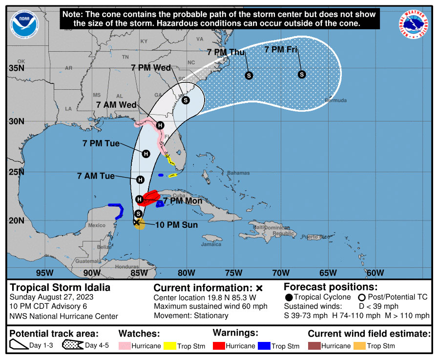
 BREVARD COUNTY, FLORIDA – National Hurricane Center’s latest report shows Tropical Storm Idalia has strengthened since the last report on Sunday.
As a result, the government of Cuba has changed the Tropical Storm Warning for Pinar del Rio to a Hurricane Warning.
Idalia has been moving erratically and is nearly stationary, according to the report.
Experts say a motion toward the north-northeast and north is expected to begin on Monday, bringing the center of Idalia over the extreme southeastern Gulf of Mexico by Monday night.
Idalia will then continue on a northward or north-northeastward path over the eastern Gulf of Mexico on Tuesday and reach the Gulf coast of Florida on Wednesday.
Buoy observations indicate that maximum sustained winds have increased to near 60 mph with higher gusts.
Additional strengthening is forecast, and Idalia is expected to become a hurricane on Monday. Idalia is likely to be near or at major hurricane intensity when it reaches the Gulf coast of Florida.
Tropical-storm-force winds extend outward up to 70 miles from the center. NOAA buoy 42056 recently reported a sustained wind of 52 mph and a gust to 60 mph.
WATCH: Governor Ron DeSantis gives update on Tropical Storm Idalia

The combination of a dangerous storm surge and the tide will cause normally dry areas near the coast to be flooded by rising waters moving inland from the shoreline. The water could reach the following heights above ground somewhere in the indicated areas if the peak surge occurs at the time of high tide…
Aucilla River, FL to Chassahowitzka, FL…7-11 ft
Chassahowitzka, FL to Anclote River, FL…6-9 ft
Ochlockonee River, FL to Aucilla River, FL…4-7 ft
Anclote River, FL to Middle of Longboat Key, FL…4-7 ft
Tampa Bay…4-7 ft
Middle of Longboat Key, FL to Englewood, FL…3-5 ft
Englewood, FL to Chokoloskee, FL…2-4 ft
Charlotte Harbor…2-4 ft
Indian Pass, FL to Ochlockonee River, FL…2-4 ft
Chokoloskee, FL to East Cape Sable, FL…1-3 ft
Florida Keys…1-2 ft
The deepest water will occur along the immediate coast in areas of onshore winds, where the surge will be accompanied by large and dangerous waves. Surge-related flooding depends on the relative timing of the surge and the tidal cycle, and can vary greatly over short distances. For information specific to your area, please see products issued by your local National Weather Service forecast office.
Storm surge will raise water levels by as much as 4 to 6 feet above normal tide levels along the southern coast of Pinar del Rio, Cuba.
Near the coast, the surge will be accompanied by large waves.
For Brevard County, the impact of Idalia would bring gusty swalls with heavy rainfall and favorable conditions for tornadoes on Tuesday and Wednesday of this week.
Gov. Ron DeSantis has declared a State of Emergency for 33 counties in Florida in anticipation of the arrival of Idalia.
National Hurricane Center says people in Florida should monitor the progress of this system.


