UPDATE: Hurricane Matthew Labeled Category 3 Hurricane, Winds Reaching To 120 MPH
By Space Coast Daily // September 30, 2016
UPDATE: Hurricane Matthew has been upgraded, once again, to a Category 3 hurricane with wind speeds reaching 120 MPH.
Storm continues to push through the west by traveling 12 mph.
Computer models reveal Matthew’s will be turning to the north by early Sunday morning
PREVIOUS STORY: SEPT 30
BREVARD COUNTY, FLORIDA – In a turn of events, Hurricane Matthew has rapidly intensified into a Category 2 hurricane sooner than weather model projections forecasted.
Reports from an Air Force Reserve Hurricane Hunter aircraft indicate that maximum sustained winds have increased to near 100 mph (155 km/h) with higher gusts.
Additional strengthening is forecast during the next 48 hours, and Matthew could become a major hurricane later today or tonight, according to the National Hurricane Center.
Matthew continues to be moving toward the west at 14 mph.
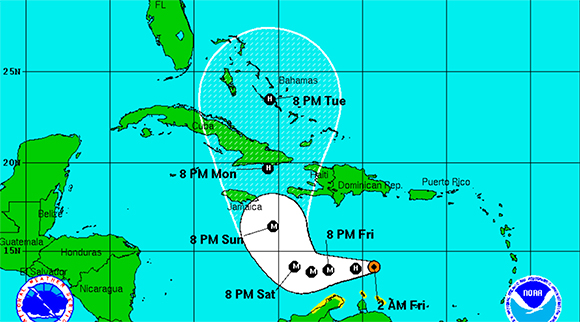
Experts and hurricane models still predict a drastic turn to the north in the coming days that would align Matthew to hit Jamaica and the Bahamas Monday morning heading into Tuesday afternoon.
ABOVE VIDEO: Space Coast Daily Special Weather Correspondent Danny Treanor offers his expert tips about surviving the upcoming hurricane season on the Space Coast. Treanor has been Central Florida’s premier weatherman for five decades. Part two below.
Matthew is a considerably wide storm, with the cloud field extending over 500 miles across.
The size of the hurricane would cover state of Florida.
Stay Tuned To Space Coast Daily For Updates
ABOVE VIDEO: Surviving hurricane season on the Space Coast part 2.


