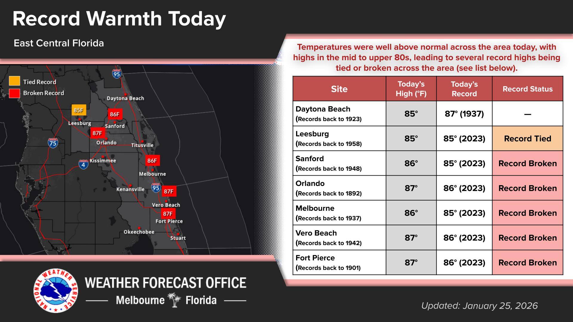
NWS: potential high winds across the Space Coast, with northwest gusts up to 60 mph possible
Brevard County residents and visitors enjoyed a sunny, warm Sunday along the Space Coast, with temperatures climbing into the lower 80s and bright skies drawing beachgoers and surfers to the shorelines. For many, it was a picture-postcard winter day — a stark contrast to much of the nation still wrestling with wintry chill. But beneath the calm skies, meteorologists are tracking a significant weather shift that is set to transform the local forecast from tonight through Monday. (NWS image)
FLORIDA’S SPACE COAST – Brevard County residents and visitors enjoyed a sunny, warm Sunday along the Space Coast, with temperatures climbing into the lower 80s and bright skies drawing beachgoers and surfers to the shorelines.
For many, it was a picture-postcard winter day — a stark contrast to much of the nation still wrestling with wintry chill.
But beneath the calm skies, meteorologists are tracking a significant weather shift that is set to transform the local forecast from tonight through Monday.
A strong cold front pushing southward across Florida is expected to sweep through Brevard County, bringing gusty northwest winds, colder air, and a notable drop in temperatures compared with the past few days’ mild warmth.
The National Weather Service has highlighted the potential for high winds across the Space Coast, with northwest gusts up to 60 mph possible Sunday into early Monday, especially in coastal and inland areas alike.
These conditions are strong enough to knock down tree limbs and disrupt travel, particularly for high-profile vehicles.
As the front passes, residents should prepare for a sharp cooldown overnight, with wind chill values potentially dipping near freezing in some inland pockets, a rarity for this region in late January. Vulnerable populations and outdoor pets may need extra protection as temperatures fall behind the front.
Forecasters say this cold air surge follows several days of above-normal temperatures across Central Florida, part of a warm pattern that saw highs climbing into the upper 70s and low 80s before the front’s arrival.
Looking beyond the immediate transition, the rest of the week is expected to settle into cooler and more seasonal conditions, with brisk winds and lower humidity lingering. The brief warm spell may feel like a distant memory as winter air settles in.
A strong cold front pushing southward across Florida is expected to sweep through Brevard County, bringing gusty northwest winds, colder air, and a notable drop in temperatures compared with the past few days’ mild warmth.
Sunday Night: Partly cloudy, with a low around 66. South southwest wind around 10 mph.
Monday: A chance of showers between 9 am and noon. Partly sunny, with a high near 78. Southwest wind 10 to 15 mph becoming west northwest in the afternoon. Winds could gust as high as 20 mph. The chance of precipitation is 40%.
Monday Night: Mostly clear, with a low around 45. Windy, with a north northwest wind 15 to 20 mph, with gusts as high as 25 mph.
Tuesday: Sunny, with a high near 58. North wind around 15 mph, with gusts as high as 25 mph.
Tuesday Night: Mostly clear, with a low around 43. North northwest wind around 10 mph.
Wednesday: Sunny, with a high near 63. North northwest wind around 10 mph.
Wednesday Night: Mostly clear, with a low around 40. Northwest wind around 10 mph.
Thursday: Sunny, with a high near 60. Northwest wind 10 to 15 mph, with gusts as high as 20 mph.
Thursday Night: Mostly clear, with a low around 44. Northwest wind around 10 mph.
Friday: Sunny, with a high near 63. Northwest wind around 10 mph.
Friday Night: Partly cloudy, with a low around 45. North northwest wind around 10 mph.
Saturday: A 30 percent chance of showers. Partly sunny, with a high near 59. North northwest wind 10 to 15 mph, with gusts as high as 20 mph.
Saturday Night: A 30 percent chance of showers. Mostly cloudy, with a low around 42. North northwest wind around 15 mph, with gusts as high as 20 mph.
Sunday: A 20 percent chance of showers. Mostly sunny, with a high near 59. North wind around 15 mph, with gusts as high as 20 mph.