TODAY’S WEATHER: Partly Sunny, Highs In Upper 50s
By Space Coast Daily // January 24, 2014
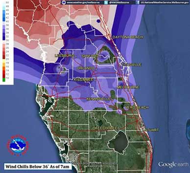
Bundle up – Wind chills in upper 20s

Friday Night: Partly cloudy. Lows in the upper 30s.
NATIONAL WEATHER SERVICE • MELBOURNE, FLORIDA – Bundle up. We’ve got a cold spell ahead.
UPCOMING FORECAST
Friday: Partly sunny. Breezy. Highs in the upper 50s. North winds 15 to 20 mph.
Friday Night: Partly cloudy. Lows in the upper 30s.
Saturday: Partly sunny. Highs in the upper 60s.
Saturday Night: Partly cloudy. Not as cool. Lows in the upper 40s.
Sunday: Partly sunny. A slight chance of afternoon showers. Highs around 70. Chance of rain 20 percent.
Sunday Night: Partly cloudy with a slight chance of showers. Lows in the mid 50s. Chance of rain 20 percent.
Monday: Partly cloudy with a slight chance of showers. Breezy. Highs in the lower 70s. Chance of rain 20 percent.
Monday Night: Partly cloudy. Breezy. Lows in the upper 40s.
Tuesday: Partly sunny. Breezy. Highs in the mid 60s.
THIS HAZARDOUS WEATHER OUTLOOK IS FOR EAST CENTRAL FLORIDA.
TONIGHT
EXCESSIVE COLD IMPACT…
A REINFORCING COLD FRONT WILL MOVE THROUGH EAST CENTRAL FLORIDA
LATE TONIGHT…WITH ANOTHER SURGE OF CHILLY NORTHWEST TO NORTHERLY
WINDS IN ITS WAKE. THIS WILL PRODUCE ANOTHER COLD NIGHT ACROSS EAST
CENTRAL FLORIDA. TEMPERATURES ARE NOT FORECAST TO REACH THE FREEZING
MARK EXCEPT FOR IN A FEW RURAL SHELTERED LOCATIONS…MAINLY NORTH OF
INTERSTATE 4. HOWEVER…WIDESPREAD LOW TEMPERATURES IN THE MIDDLE
30S TO AROUND 40 DEGREES ARE FORECAST FOR ALL BUT EASTERN MARTIN AND
COASTAL SOUTHEASTERN SAINT LUCIE COUNTIES.
THE COLD TEMPERATURES WILL COMBINE WITH WIND SPEEDS OF 10 TO 15 MPH
TO PRODUCE WIDESPREAD WIND CHILL READINGS IN THE UPPER 20S AND LOWER
30S BY SUNRISE…WITH SOME MIDDLE 20S OVER NORTHERN LAKE AND VOLUSIA
COUNTIES. IF YOU WILL BE OUTSIDE EARLY FRIDAY MORNING…YOU WILL
NEED TO DRESS APPROPRIATELY FOR THE COLD…WEARING GLOVES…A HAT
AND A SCARF. ALSO…IF USING SPACE HEATERS…KEEP THEM IN OPEN AREAS
AWAY FROM CURTAINS AND OTHER FLAMMABLE MATERIALS.
WIND AND SEA IMPACT…
IMPACTS FROM THE NORTHERLY WIND SURGE WILL PRIMARILY BE FELT ON
FRIDAY…HOWEVER GUSTY NORTHWEST TO NORTH WINDS WITH BUILDING SEAS
WILL SPREAD ACROSS THE ATLANTIC WATERS NORTH OF CAPE CANAVERAL
A FEW HOURS PRIOR TO SUNRISE.
DAYS TWO THROUGH SEVEN…FRIDAY THROUGH WEDNESDAY…
INCREASING NORTHERLY WINDS BEHIND THE BOUNDARY WILL ALSO LEAD TO
HAZARDOUS BOATING CONDITIONS ACROSS THE COASTAL WATERS BEGINNING
EARLY FRIDAY MORNING LASTING INTO FRIDAY EVENING.


