VIDEO: Sheriff Wayne Ivey Gives A Message To Residents of Brevard, Matthew Drifting Further West
By Space Coast Daily // October 4, 2016
next advisory is at 8 p.m
ABOVE VIDEO: BCSO Sheriff Wayne Ivey gives a message to Brevard County residents.
BREVARD COUNTY, FLORIDA – Hurricane Watch is still in effect for Volusia-Brevard County line south to Deerfield Beach.
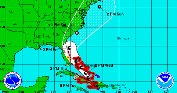
Max Sustained Winds were recorded at 140 mph, as of 5 p.m. on Tuesday.
According to the National Hurricane Center, Matthew is moving toward the north near 9 mph.
On this track the eye of Matthew will move over the extreme portion of eastern Cuba in the next few hours. A turn toward the north-northwest is expected by Wednesday, followed by a northwest turn Wednesday night.
Matthew is expected to move near or over portions of the southeastern and central Bahamas tonight and Wednesday, and approach the northwestern Bahamas Wednesday night.
National Hurricane Center shows the storm’s eyewall passing within approximately 53 miles from the Brevard County coast late Thursday evening, into the early morning hours on Friday.
 Related Story:
Sandbags Available To Brevard Residents Starting Today At Two Brevard County Locations
According to NHC, the combination of a dangerous storm surge and large and destructive waves could raise water levels by as much as the following amounts above normal tide levels.
North Palm Beach to the Volusia/Brevard county line: 3 to 5 ft
“Matthew is the greatest threat we’ve seen from a hurricane in more than a decade,” Channel 9 meteorologist Brian Shields said.
The next advisory is at 8 p.m.
STAY TUNED TO SPACE COAST DAILY FOR UPDATES