NHC: Maria Expected To Become Hurricane Later Today, Storm Tracking West-Northwest
By Space Coast Daily // September 17, 2017
Hurricane Warning is in effect for Dominica

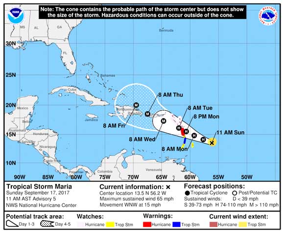
NATIONAL HURRICANE CENTER – Tropical Storm Maria is centered as of 11 a.m. AST about 450 miles east-southeast of the Leeward Islands. It’s moving toward the west-northwest near 15 mph, and this motion with a decrease in forward speed is expected through Tuesday.
On the forecast track, the center of Maria will move across the Leeward Islands Monday night.
A Hurricane Warning is in effect for Dominica.
A Tropical Storm Warning is in effect for. St. Lucia. A Hurricane Watch is in effect for Antigua, Barbuda, St. Kitts, Nevis, Montserrat, Guadeloupe, Saba and St. Eustatius, St. Maarten, St. Martin, St. Barthelemy and Anguilla.
A Tropical Storm Watch is in effect for Martinique, Barbados, St. Vincent and the Grenadines.
Maximum sustained winds are near 65 mph with higher gusts. Strengthening is forecast during the next 48 hours, and Maria is expected to become a hurricane later today. Tropical-storm-force winds extend outward up to 70 miles from the center.
 Related Story:
National Weather Service Post Storm Hurricane Irma Report Details Wind Speeds, Surges and More
Hurricane conditions are first expected within portions of the Leeward Islands by Monday night, with tropical storm conditions beginning on Monday. Hurricane conditions are possible within the hurricane watch area by Tuesday, with tropical storm conditions possible Monday night. Tropical storm conditions are possible in the tropical storm watch area Monday or Monday night.
Maria is expected to produce total rain accumulations of 6 to 12 inches with isolated maximum amounts of 20 inches across the Leeward Islands, including Puerto Rico and the U.S. and British Virgin Islands through Wednesday night.
Accumulations of 2 to 4 inches are expected for the northern and central Windward Islands. In all the above areas, these rainfall amounts could cause life-threatening flash floods and mudslides.
STAY TUNED TO SPACE COAST DAILY FOR HURRICANE UPDATES