Hurricane Milton Eye Forecast to Pass Over Central Brevard Thursday Afternoon; NWS Calls for Tropical Storm Conditions on Wednesday
By Space Coast Daily // October 9, 2024
Wednesday Night: Hurricane conditions possible. Showers and possibly a thunderstorm. Low around 76
 Related Story:
Hurricane Milton Explodes to Category 5 Hurricane Carrying 180 mph Max Sustained Winds
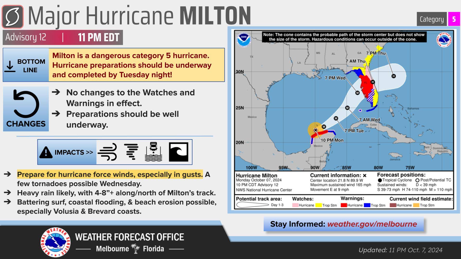
The latest forecast from the National Hurricane Center projects Brevard County could see 6 to 10 inches of rain, and sustained winds of 55 to 75 mph, with higher wind gusts of 80 mph.
BREVARD COUNTY, FLORIDA – Hurricane Milton is once again a very dangerous Cat 5 hurricane. The flooding rainfall threat has increased significantly along the I-4 corridor. Life-threatening street and urban flooding will be possible through Friday. Never drive through flooded roadways!
■ Wind Speed: Equivalent Cat 1 Hurricane force wind, Peak Wind Forecast of 55-75 mph with gusts to 85 mph.
■ Window for Tropical Storm force winds: Wednesday evening until Thursday evening.
■ Window for Hurricane force winds: Early Thursday morning until Thursday afternoon. Some roads impassable from large debris, and more within urban or heavily wooded places. Several bridges, causeways, and access routes impassable. Large areas with power and communications outages.
■ Storm Surge: Localized storm surge possible – Peak Storm Surge Inundation: The potential for up to 2 feet above ground somewhere within surge prone areas, Wednesday afternoon until Friday afternoon. Plan for storm surge flooding greater than 1 foot above ground. Complete preparations for storm surge flooding, especially in low-lying vulnerable areas, before conditions become unsafe.
■ Flood Watch is in effect, Peak Rainfall Amounts: Additional 4-8 inches, with locally higher amounts.
■ Situation is favorable for tornadoes, listen for tornado watches and warnings. If a tornado warning is issued, be ready to shelter quickly.
Space Coast residents should have their final preparations for Hurricane Milton made by Wednesday morning, and longtime Central Florida Meteorologist and Space Coast Daily correspondent Danny Treanor offers some sage advice and reminders on how to prepare for a storm. CLICK HERE TO WACH
WATCH: Live Hurricane Milton update and information with Sheriff Wayne Ivey and Emergency Management Director John Scott from earlier today.

The National Weather Service on Wednesday night into early Thursday morning calls for Tropical storm conditions, with hurricane conditions possible. Showers and possibly a thunderstorm, mainly before 1am, then a chance of showers and thunderstorms after 1am. Some of the storms could be severe and produce heavy rainfall. Low around 76. Chance of precipitation is 90%. New rainfall amounts between three quarters and one inch possible.


