
WATCH: Hurricane Milton Eye Forecast to Pass Over Brevard Thursday Morning; Sustained Winds of 50 to 60 mph, Gusts of 75 Expected
By Space Coast Daily // October 10, 2024
WATCH ZACH CLARK'S HURRICANE MILTON UPDATE ON SPACE COAST DAILY TV
WATCH: Space Coast Daily’s Zach Clark provides a Wednesday night update on Hurricane Milton.
 Related Story:
SPACE COAST DAILY TV: Watch Live Webcams Across Florida as Hurricane Milton Approaches and Impacts Florida
HURRICANE MILTON UPDATE: The latest forecast from the National Hurricane Center projects Brevard County could see 3 to 5 inches of rain, and sustained winds of 50 to 60 mph, with higher wind gusts of 75 mph on Thursday.
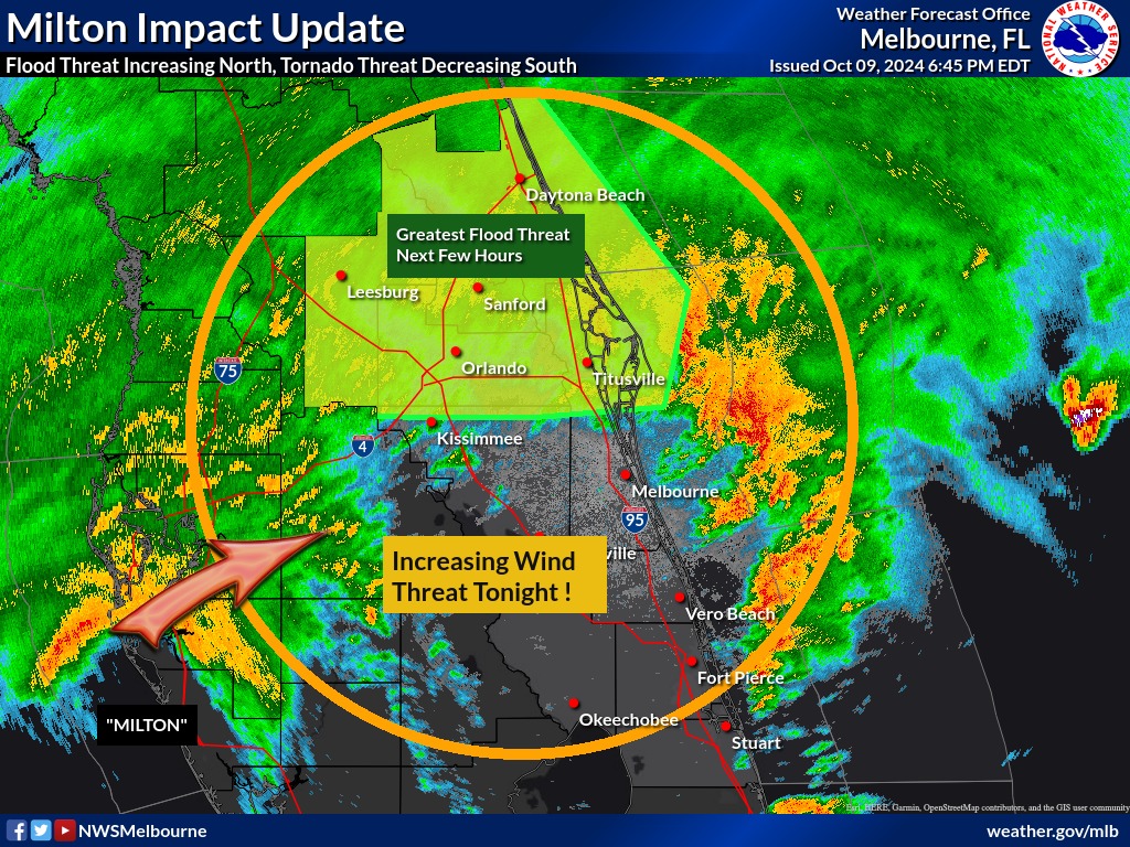
NATIONAL WEATHER SERVICE • MELBOURNE, FLORIDA – The threat of tornadoes will remain overnight but be more limited than earlier today – with the risk mainly focusing a bit farther north than the Treasure Coast where multiple touchdowns have occurred this afternoon, including Cocoa Beach.
Meanwhile, the flash flood threat is increasing along the I-4 corridor, and the strong/damaging winds associated with Milton are forecast to arrive overnight.
The National Weather Service said Wednesday night into early Thursday morning calls for Tropical storm conditions on the Space Coast, with hurricane conditions possible. Showers and possibly a thunderstorm, mainly before 1 a.m., then a chance of showers and thunderstorms after 1 a.m. Some of the storms could be severe and produce heavy rainfall. Low around 76.
Chance of precipitation is 90%. New rainfall amounts between three quarters and one inch possible.
■ Thursday: Tropical storm and possibly Hurricane conditions are expected, with hurricane conditions possible. Showers and possibly a thunderstorm. Some of the storms could produce heavy rainfall. High near 85. Chance of precipitation is 80%. New rainfall amounts between a half and three quarters of an inch possible.
■ Thursday Night: Showers likely and possibly a thunderstorm before 2 am, then a chance of showers and thunderstorms after 2am. Mostly cloudy, with a low around 75. Windy, with a north wind 20 to 25 mph, with gusts as high as 40 mph. Chance of precipitation is 60%. New rainfall amounts between a quarter and half of an inch possible.
■ Friday: A 30 percent chance of showers and thunderstorms. Mostly sunny, with a high near 84. Windy, with a north northeast wind around 20 mph, with gusts as high as 30 mph.
■ Friday Night: A 20 percent chance of showers and thunderstorms before 2am. Partly cloudy, with a low around 74. Windy, with a north northeast wind 15 to 20 mph, with gusts as high as 25 mph.
■ Saturday: Sunny, with a high near 83. North northeast wind around 15 mph, with gusts as high as 20 mph.
■ Saturday Night :Mostly clear, with a low around 72. Northeast wind 5 to 10 mph.
■ Sunday: Sunny, with a high near 83. East northeast wind 5 to 10 mph.
■ Sunday Night: Mostly clear, with a low around 71. East wind around 5 mph becoming south southeast after midnight.
■ Columbus Day: Sunny, with a high near 85. North northwest wind 5 to 10 mph becoming east in the afternoon.
■ Monday Night: Mostly clear, with a low around 71. East southeast wind around 5 mph becoming southwest after midnight.
■ Tuesday: A 20 percent chance of showers and thunderstorms. Mostly sunny, with a high near 85. West northwest wind 5 to 10 mph becoming north northeast in the afternoon.
■ Tuesday Night: A 20 percent chance of showers and thunderstorms. Mostly cloudy, with a low around 71. North northeast wind around 10 mph.
■ Wednesday: A 20 percent chance of showers. Partly sunny, with a high near 81. North northeast wind 10 to 15 mph, with gusts as high as 20 mph.