Severe Storms to Sweep Across Brevard County Tonight, Damaging Winds and Isolated Tornado Possible
By Space Coast Daily // February 15, 2026
Heavy downpours and frequent lightning are also likely
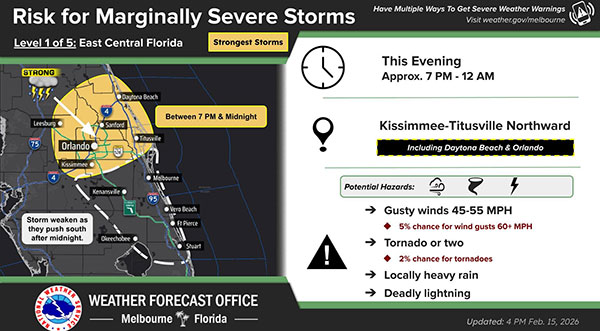
BREVARD COUNTY, FLORIDA – A line of strong to marginally severe thunderstorms is expected to sweep across the northern half of East Central Florida this evening, bringing the threat of damaging wind gusts and a possible tornado.
Forecasters say the line of storms will move through the region between 7 p.m. and midnight, primarily impacting communities north of Orlando and along the Interstate 4 corridor before gradually weakening after midnight as it pushes farther south.
The main concern with this system is damaging straight-line winds, which could down trees and power lines, along with the potential for isolated tornado development embedded within the line of storms.
Heavy downpours and frequent lightning are also likely as the storms pass.
Conditions are expected to deteriorate quickly this evening as the squall line approaches. Residents are urged to:
– Secure loose outdoor items that could become airborne in strong winds.
– Have multiple ways to receive weather warnings, especially overnight.
– Be prepared to move to an interior room on the lowest floor of a sturdy building if a Tornado Warning is issued.
The line is forecast to lose intensity after midnight as it moves into southern portions of East Central Florida, though gusty winds and periods of rain may linger into the early morning hours.
Temperatures will remain mild ahead of the storms before cooler, drier air moves in behind the system to start the new week.
Stay weather-aware this evening and monitor trusted local forecasts for updates as conditions evolve.