National Weather Service Warns Of Rip Currents
By Space Coast Daily // July 21, 2014
WARNING FOLLOWS TWO LOCAL DROWNINGS
ABOVE VIDEO: Dr. Peter Wernicki, a member of the American Red Cross Science Advisory Council talks about rip currents, what they are, how to avoid them, swim out of them, and how to spot them.
BREVARD COUNTY, FLORIDA — A higher coverage of storms is expected this afternoon and evening due to higher atmospheric moisture and instability.
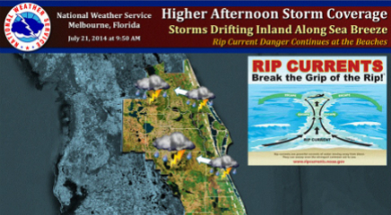
Storms will form along the sea breeze through early afternoon and drift inland with storm coverage increasing through the late afternoon.
Frequent lightning, heavy downpours due to slow storm movement and a few stronger storms with gusts to 45 mph can be expected.
Also, deep moisture and light winds may allow an isolated waterspout to form near the Treasure Coast through early afternoon.
A rip current danger continues at the East Coast beaches today. Two drownings occurred along the Brevard county coast over the weekend.
To reduce your risk, ask lifeguards about conditions when arriving at the beach and take their advice. Always swim within sight of a lifeguard. Even strong swimmers can be subject to the rip current danger.
RELATED CONTENT: BCSO Confirms Body of Missing Swimmer Found


