Tropical Storm Laura Strengthens, Path Shifts Away Further From Florida
By Space Coast Daily // August 22, 2020
Tropical Storm Watch issued for the Florida Keys
ABOVE VIDEO: The National Weather Service in Melbourne forecast on Saturday calls for a slight chance of showers, then a chance of showers and thunderstorms after noon. Partly sunny skies, with a high near 93.

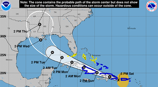
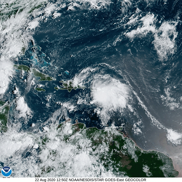
BREVARD COUNTY, FLORIDA – National Hurricane Center is closely monitoring Tropical Storm Laura on Saturday after the latest 5 p.m. report shows Laura strengthening as it moves through Puerto Rico.
In what is being described by many experts as rare weather event, Tropical Storm Laura and Tropical Storm Marco could meet up in the Gulf of Mexico at the same time on Monday.
Both storms are projected to hit nearly the same area as a hurricane around New Orleans, Louisiana.
Currently, Laura is moving to the west at 18 mph and carrying 50 max sustained winds.
What happens when Laura and Marco meet up in the Gulf is still bewildering experts as two storms of this size meeting up rarely happens.
At this point, experts are anticipating the storms to hit nearly simultaneously with Louisiana receiving the major impact of both systems.
Laura could strengthen into a category 2 hurricane by Tuesday with the possibility of reaching major hurricane status depending on how organized and strength it holds as it moves over Cuba on Monday.
A Tropical Storm Watch has been issued for the Florida Keys from Ocean Reef to Key West and for the Dry Tortugas, including Florida Bay.
The government of Cuba has issued a Tropical Storm Warning for the Cuban provinces of Camaguey, Las Tunas, Holguin, Guantanamo, Santiago de Cuba, and Granma.
The government of the Bahamas has issued a Tropical Storm Watch for Andros Island.
CLICK HERE FOR BREVARD COUNTY NEWS


